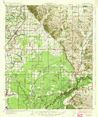
1935 Map of Sledge
USGS Topo · Published 1935About this map
Crenshaw and Sledge anchor this Delta-region survey, where the Illinois Central System railroad tracks parallel the Chickasaw Boundary Line. The landscape is a complex network of waterways, featuring the Tallahatchie River and numerous oxbow formations like Pecan Lake and Fruit Lake. This era predates significant modern flood control, showing the intricate drainage through Squirrel Bridge Bayou and the Mc Ivor Drainage Canal. Evidence of early 20th-century aviation appears at Carrier Landing Field, while the rural social fabric is visible through countless localized institutions, such as Mastodon Sch, New Bethel Sch, and Pilgrims Rest Ch. This survey provides a rare look at the transition between the upland hills and the bottomland flats, marked simply as Rough terrain where the elevations shift.
Find a feature on this map
87 named features on this map. Tap any name to fly to it.
Don’t see what you’re looking for? This feature index may not catch every label — zoom into the map to look around manually.
Map Details
Editions of this 1935 Sledge Map
2 editions found

Other maps of this area

1908 · Walnut Lake
USGS Topo · 1:24,000

1910 · Walnut Lake
USGS Topo · 1:31,680

1932 · Sledge
USGS Topo · 1:48,000

1932 · Tutwiler
USGS Topo · 1:48,000

1932 · Marks
USGS Topo · 1:48,000

1932 · Crenshaw
USGS Topo · 1:62,500

1935 · Crowder
USGS Topo · 1:62,500

1935 · Marks
USGS Topo · 1:62,500

1935 · Crenshaw
USGS Topo · 1:62,500

1935 · Tutwiler
USGS Topo · 1:62,500