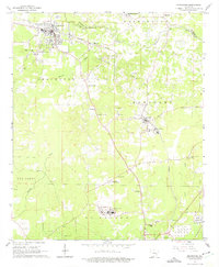
1962 Map of Smackover
USGS Topo · Published 1975About this map
The Smackover Oil and Gas Field dominates this early 1960s landscape, reflecting the heavy industrial footprint of petroleum extraction in southern Arkansas. The map illustrates a dense infrastructure of production, including numerous oil wells, several Oil Refineries, a sprawling Tank Farm, and a large Chemical Plant. These facilities are concentrated around the settlements of Smackover and Norphlet, where the Missouri Pacific railroad provided the vital transport link for the region's mineral wealth.
Find a feature on this map
39 named features on this map. Tap any name to fly to it.
Don’t see what you’re looking for? This feature index may not catch every label — zoom into the map to look around manually.
Map Details
Editions of this 1962 Smackover Map
4 editions found

Other maps of this area

1927 · El Dorado
USGS Topo · 1:62,500

1930 · El Dorado
USGS Topo · 1:62,500

1951 · El Dorado
USGS Topo · 1:62,500

1953 · El Dorado
USGS Topo · 1:250,000

1957 · El Dorado
USGS Topo · 1:250,000

1958 · El Dorado
USGS Topo · 1:250,000

1960 · El Dorado
USGS Topo · 1:250,000

1962 · Lisbon
USGS Topo · 1:24,000

1962 · Louann
USGS Topo · 1:24,000

1962 · Smackover NE
USGS Topo · 1:24,000