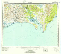
1950 Map of Solomon
USGS Topo · Published 1956About this map
The coastal frontier of the Seward Peninsula is captured here during the mid-century, revealing a landscape defined by gold mining history and Indigenous settlements along Norton Sound. Inland from the coast, the network of watercourses like the Casadepaga River and Fish River provided critical access to remote interior mining districts. Evidence of the region’s earlier boom remains visible through labels for the Big Hurrah Mine and Uncle Sam Mine, while the social infrastructure of the trail system is preserved in the presence of the Ruby Roadhouse and Portage Roadhouse. Along the eastern shore, the Native Reservation Boundary encompasses the settlement of Elim. The map traces vital transportation routes of the era, from the coastal Port Safety to the Tractor Trail and Winter Trail systems that connected isolated outposts across the Darby Mountains and the interior village of Council.
Find a feature on this map
53 named features on this map. Tap any name to fly to it.
Don’t see what you’re looking for? This feature index may not catch every label — zoom into the map to look around manually.
Map Details
Editions of this 1950 Solomon Map
5 editions found

Other maps of this area

1907 · Casadepaga
USGS Topo · 1:62,500

1907 · Solomon
USGS Topo · 1:62,500

1948 · Norton Bay
USGS Topo · 1:250,000

1950 · Bendeleben A-6
USGS Topo · 1:63,360

1950 · Bendeleben A-4
USGS Topo · 1:63,360

1950 · Bendeleben A-5
USGS Topo · 1:63,360

1950 · Bendeleben A-3
USGS Topo · 1:63,360

1950 · Bendeleben A-2
USGS Topo · 1:63,360

1950 · Bendeleben A-1
USGS Topo · 1:63,360

1950 · Solomon B-3
USGS Topo · 1:63,360