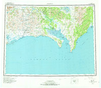
1950 Map of Solomon
USGS Topo · Published 1973About this map
The Seward Peninsula coastline and the jagged Darby Mountains define this landscape on the northern edge of Norton Sound. Historically significant outposts like Council and White Mountain sit at the confluence of the Niukluk River and Fish River, serving as interior hubs connected to the coast via rugged overland routes. The transport network of the mid-20th century relied heavily on established trails, including a Tractor Trail and various Winter Trail segments that linked remote camps such as Quigleys Camp and Lees Camp. Along the southern shore, maritime and aviation needs are marked by a Fishing Village near Golovnin Lagoon and several designated landing areas. The proximity of the Elim Native Reservation and the remote Portage Roadhouse reflects a period of transition where traditional subsistence lived alongside the logistical needs of miners and travelers.
Find a feature on this map
88 named features on this map. Tap any name to fly to it.
Don’t see what you’re looking for? This feature index may not catch every label — zoom into the map to look around manually.
Map Details
Editions of this 1950 Solomon Map
5 editions found

Other maps of this area

1907 · Casadepaga
USGS Topo · 1:62,500

1907 · Solomon
USGS Topo · 1:62,500

1948 · Norton Bay
USGS Topo · 1:250,000

1950 · Bendeleben A-6
USGS Topo · 1:63,360

1950 · Bendeleben A-4
USGS Topo · 1:63,360

1950 · Bendeleben A-5
USGS Topo · 1:63,360

1950 · Bendeleben A-3
USGS Topo · 1:63,360

1950 · Bendeleben A-2
USGS Topo · 1:63,360

1950 · Bendeleben A-1
USGS Topo · 1:63,360

1950 · Solomon B-3
USGS Topo · 1:63,360