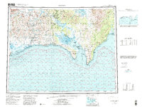
1950 Map of Solomon
USGS Topo · Published 1985About this map
Seward Peninsula reveals a landscape of maritime commerce and interior travel routes on this topographic-bathymetric study. The coastal settlement of Solomon sits near the western edge, linked to the interior by the Taylor Highway, while the community of Golovin occupies a strategic position between Golovnin Lagoon and the open waters of Golovnin Bay. Along the river valleys, the Niukluk and Fish rivers provide natural corridors for inland movement, dotted with legacy infrastructure like Ruby Roadhouse and the Golovin Mission. The map's bathymetric data extends into Norton Sound, illustrating the shallow waters of Safety Sound and the prominent headlands of Cape Nome and Cape Darby. This era of the peninsula shows a reliance on water-borne transport and established roadhouses for travel between isolated outposts like Moses Point and White Mountain.
Find a feature on this map
37 named features on this map. Tap any name to fly to it.
Don’t see what you’re looking for? This feature index may not catch every label — zoom into the map to look around manually.
Map Details
Editions of this 1950 Solomon Map
5 editions found

Other maps of this area

1907 · Casadepaga
USGS Topo · 1:62,500

1907 · Solomon
USGS Topo · 1:62,500

1948 · Norton Bay
USGS Topo · 1:250,000

1950 · Bendeleben A-6
USGS Topo · 1:63,360

1950 · Bendeleben A-4
USGS Topo · 1:63,360

1950 · Bendeleben A-5
USGS Topo · 1:63,360

1950 · Bendeleben A-3
USGS Topo · 1:63,360

1950 · Bendeleben A-2
USGS Topo · 1:63,360

1950 · Bendeleben A-1
USGS Topo · 1:63,360

1950 · Solomon B-3
USGS Topo · 1:63,360