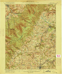
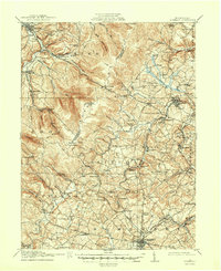
1915 Map of Somerset
USGS Topo · Published 1915About this map
Laurel Hill dominates the western topography of this 1915 survey, serving as a natural divide between the industrializing coal fields of Somerset County and the valley settlements of Westmoreland County. The map documents an era of transition where early mountain roads, such as the Pittsburgh and Philadelphia Road, coexist with expanding extraction infrastructure. Numerous coal operations are visible, including the Brenda Mine near Boswell and the Husband Mine further south, linked by a growing network of rail lines like the Ligonier Valley RR.
Find a feature on this map
95 named features on this map. Tap any name to fly to it.
Don’t see what you’re looking for? This feature index may not catch every label — zoom into the map to look around manually.
Map Details
Editions of this 1915 Somerset Map
6 editions found
Other maps of this area

1900 · Latrobe
USGS Topo · 1:62,500

1902 · Latrobe
USGS Topo · 1:62,500

1903 · Latrobe
USGS Topo · 1:62,500

1904 · Johnstown
USGS Topo · 1:62,500

1907 · Johnstown
USGS Topo · 1:62,500

1913 · Somerset
USGS Topo · 1:62,500

1914 · Windber
USGS Topo · 1:62,500

1915 · Somerset
USGS Topo · 1:62,500

1916 · Windber
USGS Topo · 1:62,500

1920 · New Florence
USGS Topo · 1:62,500