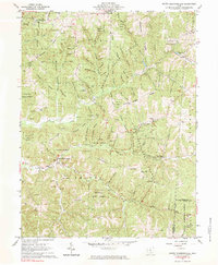
1961 Map of South Bloomingville
USGS Topo · Published 1983About this map
Queer Creek and its many tributaries, such as Spruce Run and Goose Creek, carve through the complex topography of the Hocking State Forest in this 1961 survey. The landscape is characterized by deep hollows and high ridges, including Barringer Ridge and Rocky Ridge, which dictate the placement of early settlements and road networks. The village of South Bloomingville sits at the junction of several drainage basins, serving as a local hub with the South Bloomingville Sch and nearby St Johns Chapel.
Find a feature on this map
84 named features on this map. Tap any name to fly to it.
Don’t see what you’re looking for? This feature index may not catch every label — zoom into the map to look around manually.
Map Details
Editions of this 1961 South Bloomingville Map
4 editions found
Other maps of this area

1904 · Zaleski
USGS Topo · 1:62,500

1907 · Zaleski
USGS Topo · 1:62,500

1907 · Logan
USGS Topo · 1:62,500

1907 · Lancaster
USGS Topo · 1:62,500

1909 · Lancaster
USGS Topo · 1:62,500

1909 · Logan
USGS Topo · 1:62,500

1910 · Laurelville
USGS Topo · 1:62,500

1912 · Laurelville
USGS Topo · 1:62,500

1944 · Laurelville
USGS Topo · 1:62,500

1947 · Columbus
USGS Topo · 1:250,000