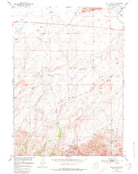
1951 Map of Split Rock NW
USGS Topo · Published 1980About this map
Green Mountain and the Owl Hills dominate the southern portion of this mid-century survey, where the high desert terrain of Fremont County meets the foothills of the Granite Mountains. The landscape is defined by the drainage systems of Cottonwood Creek and its various forks, which flow northward toward the Sweetwater R valley. This area represents a classic Wyoming rangeland environment, where the scarcity of water is managed through features like the McIntosh Beaton Ditch. Remote windmills dot the plains, supporting livestock operations in a region where Splitrock serves as a primary topographic landmark. The map documents the early alignment of U.S. Route 287 as it traverses the northern plains, providing a vital transportation link through the high country before the modern interstate era.
Find a feature on this map
16 named features on this map. Tap any name to fly to it.
Don’t see what you’re looking for? This feature index may not catch every label — zoom into the map to look around manually.
Map Details
Editions of this 1951 Split Rock NW Map
5 editions found
Other maps of this area

1951 · Crooks Creek NE
USGS Topo · 1:24,000

1951 · Stampede Meadow
USGS Topo · 1:24,000

1951 · Black Rock Gap
USGS Topo · 1:24,000

1951 · Split Rock
USGS Topo · 1:24,000

1951 · Split Rock NW
USGS Topo · 1:24,000

1951 · Lankin Dome
USGS Topo · 1:24,000

1955 · Casper
USGS Topo · 1:250,000

1957 · Jeffrey City
USGS Topo · 1:24,000

1958 · Casper
USGS Topo · 1:250,000

1961 · Crooks Peak
USGS Topo · 1:24,000