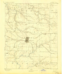
1886 Map of Springfield
USGS Topo · Published 1927About this map
Springfield sits at the heart of this late-19th-century landscape, appearing as a growing hub where the St. Louis and San Francisco Railroad and the Kansas City Fort Scott and Gulf Railroad intersect. The surrounding countryside is divided into smaller townships like Campbell and Robberson, dotted with rural post offices and small settlements such as Ebenezer and Cave Spring. The terrain is defined by the drainage patterns of the North Dry Sac Creek and Wilson Creek, which influenced early road placement and agricultural settlement before the heavy modernization of the 20th century. Local history researchers can identify the exact placement of vanished stops and depots like Dorchester and Junction City along the rail lines, providing a detailed record of the region's transport-driven economy during the 1880s.
Find a feature on this map
66 named features on this map. Tap any name to fly to it.
Don’t see what you’re looking for? This feature index may not catch every label — zoom into the map to look around manually.
Map Details
Editions of this 1886 Springfield Map
5 editions found
Other maps of this area

1884 · Springfield
USGS Topo · 1:125,000

1884 · Bolivar
USGS Topo · 1:125,000

1886 · Stockton
USGS Topo · 1:125,000

1886 · Greenfield
USGS Topo · 1:125,000

1886 · Springfield
USGS Topo · 1:125,000

1888 · Greenfield
USGS Topo · 1:125,000

1892 · Bolivar
USGS Topo · 1:125,000

1907 · Forsyth
USGS Topo · 1:125,000

1919 · Halltown
USGS Topo · 1:62,500

1935 · Springfield
USGS Topo · 1:24,000