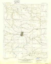
1886 Map of Springfield
USGS Topo · Published 1950About this map
The growing city of Springfield serves as the central hub for Southwest Missouri in this late nineteenth-century survey, revealing a landscape defined by the convergence of major rail lines and rural townships. Three primary rail corridors—the St. Louis and San Francisco Railroad, Kansas City and Scott Railroad, and Gulf Railroad—radiate from the city center, facilitating the transport of agricultural goods and lead from the surrounding Ozark plateaus.
Find a feature on this map
70 named features on this map. Tap any name to fly to it.
Don’t see what you’re looking for? This feature index may not catch every label — zoom into the map to look around manually.
Map Details
Editions of this 1886 Springfield Map
5 editions found
Other maps of this area

1884 · Springfield
USGS Topo · 1:125,000

1884 · Bolivar
USGS Topo · 1:125,000

1886 · Stockton
USGS Topo · 1:125,000

1886 · Greenfield
USGS Topo · 1:125,000

1886 · Springfield
USGS Topo · 1:125,000

1888 · Greenfield
USGS Topo · 1:125,000

1892 · Bolivar
USGS Topo · 1:125,000

1907 · Forsyth
USGS Topo · 1:125,000

1919 · Halltown
USGS Topo · 1:62,500

1935 · Springfield
USGS Topo · 1:24,000