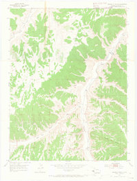
1952 Map of Square S Ranch
USGS Topo · Published 1965About this map
Square S Ranch serves as a primary landmark in this portion of Rio Blanco County, where the landscape is defined by the winding course of Piceance Creek and an intricate network of erosional drainage features. Based on field checks from the early 1950s, the map illustrates a sparsely populated ranching territory characterized by high ridges and deep gulches. Notable terrain features like Dudley Bluffs and Miller Hill rise above the drainage floors, while evidence of early land management appears through labels for a Windmill and the VABM 6794 Tower. The survey also preserves the location of the Miller Hill Cem, a vital site for local genealogical research. Water sources are critical here, with named features such as Yellow Creek, Duck Cr, and various springs supporting the isolated ranching operations of the era.
Find a feature on this map
21 named features on this map. Tap any name to fly to it.
Don’t see what you’re looking for? This feature index may not catch every label — zoom into the map to look around manually.
Map Details
Editions of this 1952 Square S Ranch Map
5 editions found
Other maps of this area

1907 · White River
USGS Topo · 1:125,000

1910 · White River
USGS Topo · 1:125,000

1952 · Wolf Ridge
USGS Topo · 1:24,000

1952 · Yankee Gulch
USGS Topo · 1:24,000

1952 · Rock School
USGS Topo · 1:24,000

1952 · Jessup Gulch
USGS Topo · 1:24,000

1952 · Greasewood Gulch
USGS Topo · 1:24,000

1952 · Square S Ranch
USGS Topo · 1:24,000

1954 · Vernal
USGS Topo · 1:250,000

1956 · Grand Junction
USGS Topo · 1:250,000