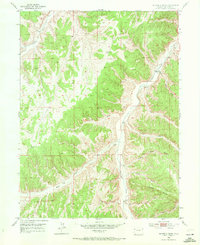
1952 Map of Square S Ranch
USGS Topo · Published 1972About this map
Piceance Creek carves a deep valley through the center of this Rio Blanco County landscape, serving as the primary corridor for movement and settlement during the mid-20th century. Near the intersection of these narrow canyon floors, the Square S Ranch stands as a focal point of the local ranching economy, situated near several natural springs and the junction of Bear Gulch. The terrain is characterized by a complex network of draws and gulches, including Horse Draw and Hog Draw, which reveal the erosive patterns of the high plateau country. Evidence of earlier family settlement and the permanence of rural life is found at the Miller Hill Cem located near Miller Hill in the southern portion of the quadrangle. Other features like the Windmill and a tower at VABM 6794 Tower provide specific navigation points for those studying the historical land use of this isolated ranching district.
Find a feature on this map
57 named features on this map. Tap any name to fly to it.
Don’t see what you’re looking for? This feature index may not catch every label — zoom into the map to look around manually.
Map Details
Editions of this 1952 Square S Ranch Map
5 editions found
Other maps of this area

1907 · White River
USGS Topo · 1:125,000

1910 · White River
USGS Topo · 1:125,000

1952 · Wolf Ridge
USGS Topo · 1:24,000

1952 · Yankee Gulch
USGS Topo · 1:24,000

1952 · Rock School
USGS Topo · 1:24,000

1952 · Jessup Gulch
USGS Topo · 1:24,000

1952 · Greasewood Gulch
USGS Topo · 1:24,000

1952 · Square S Ranch
USGS Topo · 1:24,000

1954 · Vernal
USGS Topo · 1:250,000

1956 · Grand Junction
USGS Topo · 1:250,000