
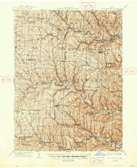
1905 Map of St. Clairsville
USGS Topo · Published 1942About this map
The National Road serves as the primary east-west artery across this early twentieth-century landscape, passing through St. Clairsville and East Richland. The topography is defined by the deeply etched drainage basins of Short Creek, Wheeling Creek, and McMahon Creek, which dictate the paths of the region's prominent rail lines. The Wheeling and Lake Erie RR and the Cleveland Lorain and Wheeling RR follow the winding creek beds to serve industrial and agricultural outposts like Adena, Dunglen, and Maynard. Genealogists will find a network of small settlements and post offices such as Short Cr. P.O. and Emerson P.O., while family-named landmarks like Galloway Knob and Clark Hill provide specific geographical anchors for local heritage research in Belmont and Jefferson Counties.
Find a feature on this map
88 named features on this map. Tap any name to fly to it.
Don’t see what you’re looking for? This feature index may not catch every label — zoom into the map to look around manually.
Map Details
Editions of this 1905 St. Clairsville Map
2 editions found
Other maps of this area

1901 · Cadiz
USGS Topo · 1:62,500

1902 · Wheeling
USGS Topo · 1:62,500

1902 · Scio
USGS Topo · 1:62,500

1903 · Cadiz
USGS Topo · 1:62,500

1903 · Flushing
USGS Topo · 1:62,500

1904 · Steubenville
USGS Topo · 1:62,500

1904 · Cameron
USGS Topo · 1:62,500

1904 · Scio
USGS Topo · 1:62,500

1905 · Clarington
USGS Topo · 1:62,500

1905 · Woodsfield
USGS Topo · 1:62,500