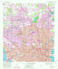
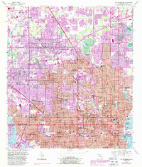
1956 Map of St Petersburg
USGS Topo · Published 1982About this map
St Petersburg stands as a dense grid of mid-century development on the Pinellas Peninsula, flanked by Tampa Bay and Boca Ciega Bay. This 1956 survey, updated with purple revisions from 1979, illustrates the rapid urban expansion into places like Pinellas Park and Kenneth City. The landscape is a network of small lakes and man-made basins, including Mirror Lake and the North Yacht Basin, which provided essential waterfront infrastructure for the growing city.
Find a feature on this map
96 named features on this map. Tap any name to fly to it.
Don’t see what you’re looking for? This feature index may not catch every label — zoom into the map to look around manually.
Map Details
Editions of this 1956 St Petersburg Map
5 editions found
Other maps of this area

1921 · Sand Key
USGS Topo · 1:62,500

1921 · Fort De Soto
USGS Topo · 1:62,500

1921 · St Petersburg
USGS Topo · 1:62,500

1942 · Cockroach Bay
USGS Topo · 1:31,680

1943 · St Petersburg
USGS Topo · 1:31,680

1943 · Gandy Bridge
USGS Topo · 1:31,680

1943 · Pass-A-Grille
USGS Topo · 1:31,680

1943 · Bay Pines
USGS Topo · 1:31,680

1943 · Safety Harbor
USGS Topo · 1:31,680

1943 · Port Tampa
USGS Topo · 1:31,680