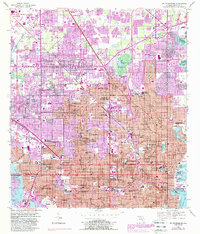
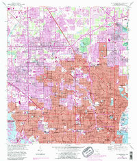
1956 Map of St. Petersburg
USGS Topo · Published 1988About this map
ST Petersburg and its surrounding communities are documented here during a period of significant mid-century expansion across the Pinellas peninsula. The urban grid extends from the shores of Tampa Bay and Bayboro Harbor westward toward Boca Ciega Bay, showcasing the early development of Kenneth City, Pinellas Park, and South Pasadena. This era highlights a robust educational landscape, featuring St Petersburg Jr College, Farragut Academy, and numerous neighborhood schools like Lealman Ave Sch and Rio Vista Sch. Waterfront activity is centered around the Municipal Pier and the North Yacht Basin, while the inland geography is marked by the presence of a Reclaimed Strip Mine and the Pinellas Lookout Tower. The infrastructure of the time is visible in the CSX rail lines and the Treasure Causeway, illustrating the connectivity between the growing residential blocks and the coastal areas.
Find a feature on this map
94 named features on this map. Tap any name to fly to it.
Don’t see what you’re looking for? This feature index may not catch every label — zoom into the map to look around manually.
Map Details
Editions of this 1956 St. Petersburg Map
5 editions found
Other maps of this area

1921 · Sand Key
USGS Topo · 1:62,500

1921 · Fort De Soto
USGS Topo · 1:62,500

1921 · St Petersburg
USGS Topo · 1:62,500

1942 · Cockroach Bay
USGS Topo · 1:31,680

1943 · St Petersburg
USGS Topo · 1:31,680

1943 · Gandy Bridge
USGS Topo · 1:31,680

1943 · Pass-A-Grille
USGS Topo · 1:31,680

1943 · Bay Pines
USGS Topo · 1:31,680

1943 · Safety Harbor
USGS Topo · 1:31,680

1943 · Port Tampa
USGS Topo · 1:31,680