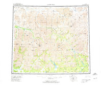
1956 Map of Survey Pass
USGS Topo · Published 1974About this map
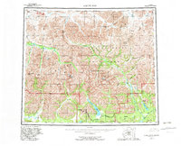
The Continental Divide carves a jagged path through the heart of the Brooks Range on this mid-century survey. The landscape is dominated by the granite spires of the Arrigetch Peaks and the massive profile of Mount Igikpak, the highest point in the region. This is a wilderness of dramatic vertical relief, where high mountain passes like Survey Pass and Kutuk Pass connect the headwaters of major arctic river systems, including the Noatak River and the Alatna River.
Find a feature on this map
79 named features on this map. Tap any name to fly to it.
Don’t see what you’re looking for? This feature index may not catch every label — zoom into the map to look around manually.
Map Details
Editions of this 1956 Survey Pass Map
7 editions found

Other maps of this area

1951 · Shungnak
USGS Topo · 1:250,000

1951 · Hughes
USGS Topo · 1:250,000

1951 · Bettles
USGS Topo · 1:250,000

1951 · Survey Pass
USGS Topo · 1:250,000

1951 · Chandler Lake
USGS Topo · 1:250,000

1951 · Howard Pass
USGS Topo · 1:250,000

1951 · Ambler River
USGS Topo · 1:250,000

1951 · Killik River
USGS Topo · 1:250,000

1951 · Wiseman
USGS Topo · 1:250,000

1955 · Shungnak
USGS Topo · 1:250,000