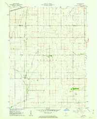
1961 Map of Tab
USGS Topo · Published 1976About this map
Agricultural development and rail logistics characterize this portion of Warren County during the early 1960s. The small settlement of Tab serves as a focal point for local commerce, evidenced by the prominent Elevators and Storage Bins situated along the New York Central railroad line. This infrastructure reflects the region's reliance on efficient grain transport from the surrounding prairie. To the north, the New York Chicago and St Louis line cuts across the landscape near Goose Creek.
Find a feature on this map
21 named features on this map. Tap any name to fly to it.
Don’t see what you’re looking for? This feature index may not catch every label — zoom into the map to look around manually.
Map Details
Editions of this 1961 Tab Map
4 editions found
Other maps of this area

1933 · Hoopeston
USGS Topo · 1:48,000

1938 · Milford
USGS Topo · 1:48,000

1938 · Hoopeston
USGS Topo · 1:62,500

1944 · Milford
USGS Topo · 1:62,500

1953 · Danville
USGS Topo · 1:250,000

1955 · Danville
USGS Topo · 1:250,000

1956 · Danville
USGS Topo · 1:250,000

1961 · Tab
USGS Topo · 1:24,000

1961 · Pine Village
USGS Topo · 1:24,000

1961 · West Lebanon
USGS Topo · 1:24,000