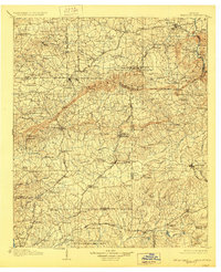
1907 Map of Talbotton
USGS Topo · Published 1928About this map
Pine Mountain and Oak MTN dominate this West Georgia landscape, creating a dramatic series of gaps and ridges that shaped the region's early road and rail networks. This early 20th-century survey documents a dense rural tapestry of family-owned landmarks and vital community centers, such as The Cove Academy and the US Fish Hatchery Cold Spring near Bullochville. The abundance of crossroads settlements like Goodmans Crossroads and Barnes Crossroads underscores the importance of local commerce at sites like Wisdoms Store and Floyd Store.
Find a feature on this map
120 named features on this map. Tap any name to fly to it.
Don’t see what you’re looking for? This feature index may not catch every label — zoom into the map to look around manually.
Map Details
Editions of this 1907 Talbotton Map
3 editions found
Other maps of this area

1899 · Wedowee
USGS Topo · 1:125,000

1902 · Wedowee
USGS Topo · 1:125,000

1907 · Talbotton
USGS Topo · 1:125,000

1907 · Opelika
USGS Topo · 1:125,000

1908 · Columbus
USGS Topo · 1:62,500

1909 · Opelika
USGS Topo · 1:125,000

1914 · Seale
USGS Topo · 1:62,500

1929 · Columbus
USGS Topo · 1:48,000

1934 · Warm Springs
USGS Topo · 1:62,500

1935 · Thomaston
USGS Topo · 1:48,000