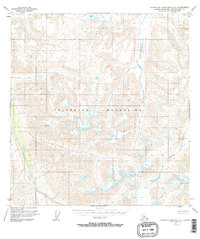
1951 Map of Talkeetna Mountains B-3
USGS Topo · Published 1968About this map
The Talkeetna Mountains dominate this high-altitude landscape in the Matanuska-Susitna region, as documented by aerial photography from 1950. The terrain is defined by a dense network of glacial and snow-fed drainages that feed the Talkeetna River in the west and the Black River to the east. Notable tributaries including Kosina Creek, Aspen Creek, and John Creek carve deep valleys through the mountain massif. This 1951 survey illustrates a wilderness state before any established roads or trails were recorded, offering a baseline for environmental researchers and historians interested in the hydrological patterns of the Alaskan interior during the mid-20th century. The intricate contour work reveals a complex system of ridges and high basins, including the headwaters of George Creek and Clear Creek.
Find a feature on this map
9 named features on this map. Tap any name to fly to it.
Don’t see what you’re looking for? This feature index may not catch every label — zoom into the map to look around manually.
Map Details
Editions of this 1951 Talkeetna Mountains B-3 Map
4 editions found
Other maps of this area

1949 · Talkeetna Mountains A-4
USGS Topo · 1:63,360

1950 · Talkeetna Mountains
USGS Topo · 1:250,000

1950 · Talkeetna Mountains B-4
USGS Topo · 1:63,360

1951 · Talkeetna Mountains A-2
USGS Topo · 1:63,360

1951 · Talkeetna Mountains C-2
USGS Topo · 1:63,360

1951 · Talkeetna Mountains B-3
USGS Topo · 1:63,360

1951 · Talkeetna Mountains A-3
USGS Topo · 1:63,360

1951 · Talkeetna Mountains B-2
USGS Topo · 1:63,360

1951 · Talkeetna Mountains C-4
USGS Topo · 1:63,360

1951 · Talkeetna Mountains C-3
USGS Topo · 1:63,360