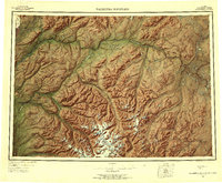
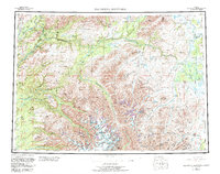
1954 Map of Talkeetna Mountains
USGS Topo · Published 1956About this map
Glacial ice and high-altitude drainage systems dominate this mid-century survey of the Talkeetna Mountains. Massive ice fields like the Eldridge Glacier, Talkeetna Glacier, and Chickaloon Glacier feed a network of powerful waterways, including the Susitna River and Talkeetna River. Along the western edge, the Alaska Railroad provides the primary corridor for human activity, connecting small sidings and outposts such as Sherman, Gold Creek, and Hurricane. The interior remains largely defined by its natural features, with high peaks like Bald Mountain and isolated landmarks such as Lone Butte rising above the timberline. Further east, the terrain transitions into lake-heavy country, where Stephan Lake, Fog Lakes, and Watana Lake are situated between the river valleys of the Oschetna River and Maclaren River.
Find a feature on this map
56 named features on this map. Tap any name to fly to it.
Don’t see what you’re looking for? This feature index may not catch every label — zoom into the map to look around manually.
Map Details
Editions of this 1954 Talkeetna Mountains Map
7 editions found

Other maps of this area

1948 · Anchorage D-3
USGS Topo · 1:63,360

1948 · Anchorage D-2
USGS Topo · 1:63,360

1948 · Anchorage D-4
USGS Topo · 1:63,360

1948 · Anchorage D-1
USGS Topo · 1:63,360

1949 · Tyonek
USGS Topo · 1:250,000

1949 · Talkeetna Mountains D-6
USGS Topo · 1:63,360

1949 · Anchorage D-5
USGS Topo · 1:63,360

1949 · Anchorage D-7
USGS Topo · 1:63,360

1949 · Talkeetna Mountains B-6
USGS Topo · 1:63,360

1949 · Talkeetna Mountains A-1
USGS Topo · 1:63,360