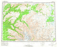
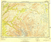
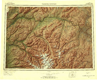
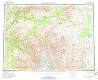
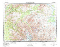
1954 Map of Talkeetna Mountains
USGS Topo · Published 1966About this map
The Alaska Railroad carves a critical path through the western edge of this vast interior landscape, connecting remote outposts like Hurricane, Chulitna, and Sherman during the mid-1950s. This survey illustrates the intricate drainage system of the Talkeetna Mountains, where the Susitna River and Talkeetna River define the valley floors between massive peaks. High-elevation features such as Talkeetna Glacier and Chickaloon Glacier feed the braided river networks that characterize the region's geography.
Find a feature on this map
59 named features on this map. Tap any name to fly to it.
Don’t see what you’re looking for? This feature index may not catch every label — zoom into the map to look around manually.
Map Details
Editions of this 1954 Talkeetna Mountains Map
7 editions found

Historical Maps of Chulitna Through Time
1048 maps found

1948 Anchorage D-1
Matanuska-Susitna Borough, AK

1948 Anchorage D-2
Matanuska-Susitna Borough, AK

1948 Anchorage D-3
Matanuska-Susitna Borough, AK

1948 Anchorage D-4
Matanuska-Susitna Borough, AK

1949 Anchorage D-5
Matanuska-Susitna Borough, AK

1949 Anchorage D-7
Matanuska-Susitna Borough, AK

1949 Anchorage D-8
Matanuska-Susitna Borough, AK

1949 Gulkana A-5
Matanuska-Susitna Borough, AK

1949 Gulkana A-6
Matanuska-Susitna Borough, AK

1949 Healy A-1
Matanuska-Susitna Borough, AK

1949 Healy A-6
Matanuska-Susitna Borough, AK

1949 Mount Hayes A-5
Matanuska-Susitna Borough, AK

1949 Talkeetna Mountains A-1
Matanuska-Susitna Borough, AK

1949 Talkeetna Mountains A-4
Matanuska-Susitna Borough, AK

1949 Talkeetna Mountains B-6
Matanuska-Susitna Borough, AK

1949 Talkeetna Mountains C-6
Matanuska-Susitna Borough, AK

1949 Talkeetna Mountains D-6
Matanuska-Susitna Borough, AK

1949 Valdez D-8
Matanuska-Susitna Borough, AK

1950 Anchorage C-7
Matanuska-Susitna Borough, AK

1950 Anchorage C-8
Matanuska-Susitna Borough, AK

1950 Anchorage D-6
Matanuska-Susitna Borough, AK

1950 Gulkana B-6
Matanuska-Susitna Borough, AK

1950 Healy A-3
Matanuska-Susitna Borough, AK

1950 Healy A-4
Matanuska-Susitna Borough, AK

1950 Healy A-5
Matanuska-Susitna Borough, AK

1950 Healy B-1
Matanuska-Susitna Borough, AK

1950 Mt. Hayes A-6
Matanuska-Susitna Borough, AK

1950 Talkeetna Mountains A-5
Matanuska-Susitna Borough, AK

1950 Talkeetna Mountains A-6
Matanuska-Susitna Borough, AK

1950 Talkeetna Mountains B-4
Matanuska-Susitna Borough, AK

1950 Talkeetna Mountains B-5
Matanuska-Susitna Borough, AK

1950 Talkeetna Mountains C-5
Matanuska-Susitna Borough, AK

1950 Talkeetna Mountains D-5
Matanuska-Susitna Borough, AK

1950 Talkeetna Mountains
Matanuska-Susitna Borough, AK

1951 Anchorage C-5
Matanuska-Susitna Borough, AK

1951 Anchorage C-6
Matanuska-Susitna Borough, AK

1951 Anchorage C-7
Matanuska-Susitna Borough, AK

1951 Anchorage D-1
Matanuska-Susitna Borough, AK

1951 Anchorage D-7
Matanuska-Susitna Borough, AK

1951 Anchorage D-8
Matanuska-Susitna Borough, AK

1951 Gulkana B-5
Matanuska-Susitna Borough, AK

1951 Gulkana C-5
Matanuska-Susitna Borough, AK

1951 Gulkana C-6
Matanuska-Susitna Borough, AK

1951 Gulkana D-5
Matanuska-Susitna Borough, AK

1951 Gulkana D-6
Matanuska-Susitna Borough, AK

1951 Gulkana
Matanuska-Susitna Borough, AK

1951 Healy A-2
Matanuska-Susitna Borough, AK

1951 Mount Hayes B-5
Matanuska-Susitna Borough, AK

1951 Mount Hayes B-6
Matanuska-Susitna Borough, AK

1951 Talkeetna B-1
Matanuska-Susitna Borough, AK

1951 Talkeetna C-1
Matanuska-Susitna Borough, AK

1951 Talkeetna Mountains A-2
Matanuska-Susitna Borough, AK

1951 Talkeetna Mountains A-3
Matanuska-Susitna Borough, AK

1951 Talkeetna Mountains B-1
Matanuska-Susitna Borough, AK

1951 Talkeetna Mountains B-2
Matanuska-Susitna Borough, AK

1951 Talkeetna Mountains B-3
Matanuska-Susitna Borough, AK

1951 Talkeetna Mountains C-1
Matanuska-Susitna Borough, AK

1951 Talkeetna Mountains C-2
Matanuska-Susitna Borough, AK

1951 Talkeetna Mountains C-3
Matanuska-Susitna Borough, AK

1951 Talkeetna Mountains C-4
Matanuska-Susitna Borough, AK

1951 Talkeetna Mountains D-1
Matanuska-Susitna Borough, AK

1951 Talkeetna Mountains D-2
Matanuska-Susitna Borough, AK

1951 Talkeetna Mountains D-3
Matanuska-Susitna Borough, AK

1951 Talkeetna Mountains D-4
Matanuska-Susitna Borough, AK

1951 Talkeetna Mountains D-5
Matanuska-Susitna Borough, AK

1951 Talkeetna Mountains D-6
Matanuska-Susitna Borough, AK

1952 Anchorage B-8
Matanuska-Susitna Borough, AK

1952 Anchorage C-5
Matanuska-Susitna Borough, AK

1952 Anchorage C-7
Matanuska-Susitna Borough, AK

1952 Anchorage C-8
Matanuska-Susitna Borough, AK

1952 Anchorage D-2
Matanuska-Susitna Borough, AK

1952 Anchorage D-3
Matanuska-Susitna Borough, AK

1952 Anchorage D-4
Matanuska-Susitna Borough, AK

1952 Anchorage D-5
Matanuska-Susitna Borough, AK

1952 Anchorage D-6
Matanuska-Susitna Borough, AK

1952 Anchorage D-7
Matanuska-Susitna Borough, AK

1952 Anchorage D-8
Matanuska-Susitna Borough, AK

1952 Gulkana A-5
Matanuska-Susitna Borough, AK

1952 Gulkana A-6
Matanuska-Susitna Borough, AK

1952 Gulkana B-5
Matanuska-Susitna Borough, AK

1952 Gulkana B-6
Matanuska-Susitna Borough, AK

1952 Gulkana C-5
Matanuska-Susitna Borough, AK

1952 Gulkana C-6
Matanuska-Susitna Borough, AK

1952 Gulkana D-5
Matanuska-Susitna Borough, AK

1952 Gulkana D-6
Matanuska-Susitna Borough, AK

1952 Healy A-1
Matanuska-Susitna Borough, AK

1952 Healy A-2
Matanuska-Susitna Borough, AK

1952 Healy A-3
Matanuska-Susitna Borough, AK

1952 Healy A-4
Matanuska-Susitna Borough, AK

1952 Healy A-5
Matanuska-Susitna Borough, AK

1952 Healy B-1
Matanuska-Susitna Borough, AK

1952 Mount Hayes A-5
Matanuska-Susitna Borough, AK

1952 Mount Hayes A-6
Matanuska-Susitna Borough, AK

1952 Talkeetna A-1
Matanuska-Susitna Borough, AK

1952 Talkeetna Mountains A-1
Matanuska-Susitna Borough, AK

1952 Talkeetna Mountains A-2
Matanuska-Susitna Borough, AK

1952 Talkeetna Mountains A-3
Matanuska-Susitna Borough, AK

1952 Talkeetna Mountains A-5
Matanuska-Susitna Borough, AK

1952 Talkeetna Mountains A-6
Matanuska-Susitna Borough, AK

1952 Talkeetna Mountains B-1
Matanuska-Susitna Borough, AK

1952 Talkeetna Mountains B-2
Matanuska-Susitna Borough, AK

1952 Talkeetna Mountains B-3
Matanuska-Susitna Borough, AK

1952 Talkeetna Mountains B-4
Matanuska-Susitna Borough, AK

1952 Talkeetna Mountains B-5
Matanuska-Susitna Borough, AK

1952 Talkeetna Mountains B-6
Matanuska-Susitna Borough, AK

1952 Talkeetna Mountains C-1
Matanuska-Susitna Borough, AK

1952 Talkeetna Mountains C-2
Matanuska-Susitna Borough, AK

1952 Talkeetna Mountains C-3
Matanuska-Susitna Borough, AK

1952 Talkeetna Mountains C-4
Matanuska-Susitna Borough, AK

1952 Talkeetna Mountains C-5
Matanuska-Susitna Borough, AK

1952 Talkeetna Mountains C-6
Matanuska-Susitna Borough, AK

1952 Talkeetna Mountains D-1
Matanuska-Susitna Borough, AK

1952 Talkeetna Mountains D-2
Matanuska-Susitna Borough, AK

1952 Talkeetna Mountains D-4
Matanuska-Susitna Borough, AK

1952 Talkeetna Mountains D-6
Matanuska-Susitna Borough, AK

1952 Tyonek C-1
Matanuska-Susitna Borough, AK

1952 Tyonek D-1
Matanuska-Susitna Borough, AK

1952 Valdez D-8
Matanuska-Susitna Borough, AK

1952 Valdez
Matanuska-Susitna Borough, AK

1953 Anchorage B-8
Matanuska-Susitna Borough, AK

1953 Healy A-6
Matanuska-Susitna Borough, AK

1953 Talkeetna Mountains D-3
Matanuska-Susitna Borough, AK

1954 Healy B-6
Matanuska-Susitna Borough, AK

1954 Mount McKinley A-1
Matanuska-Susitna Borough, AK

1954 Talkeetna A-2
Matanuska-Susitna Borough, AK

1954 Talkeetna A-3
Matanuska-Susitna Borough, AK

1954 Talkeetna A-4
Matanuska-Susitna Borough, AK

1954 Talkeetna B-2
Matanuska-Susitna Borough, AK

1954 Talkeetna B-3
Matanuska-Susitna Borough, AK

1954 Talkeetna B-4
Matanuska-Susitna Borough, AK

1954 Talkeetna Mountains A-4
Matanuska-Susitna Borough, AK

1954 Talkeetna Mountains
Matanuska-Susitna Borough, AK

1954 Tyonek B-4
Matanuska-Susitna Borough, AK

1954 Tyonek C-3
Matanuska-Susitna Borough, AK

1954 Tyonek C-4
Matanuska-Susitna Borough, AK

1954 Tyonek C-5
Matanuska-Susitna Borough, AK

1954 Tyonek D-1
Matanuska-Susitna Borough, AK

1954 Tyonek D-2
Matanuska-Susitna Borough, AK

1954 Tyonek D-3
Matanuska-Susitna Borough, AK

1954 Tyonek D-4
Matanuska-Susitna Borough, AK

1954 Tyonek D-5
Matanuska-Susitna Borough, AK

1957 Talkeetna Mountains
Matanuska-Susitna Borough, AK

1958 Talkeetna A-1
Matanuska-Susitna Borough, AK

1958 Talkeetna A-5
Matanuska-Susitna Borough, AK

1958 Talkeetna A-6
Matanuska-Susitna Borough, AK

1958 Talkeetna B-1
Matanuska-Susitna Borough, AK

1958 Talkeetna B-5
Matanuska-Susitna Borough, AK

1958 Talkeetna B-6
Matanuska-Susitna Borough, AK

1958 Talkeetna C-1
Matanuska-Susitna Borough, AK

1958 Talkeetna C-2
Matanuska-Susitna Borough, AK

1958 Talkeetna C-3
Matanuska-Susitna Borough, AK

1958 Talkeetna C-4
Matanuska-Susitna Borough, AK

1958 Talkeetna C-5
Matanuska-Susitna Borough, AK

1958 Talkeetna C-6
Matanuska-Susitna Borough, AK

1958 Talkeetna D-1
Matanuska-Susitna Borough, AK

1958 Talkeetna D-2
Matanuska-Susitna Borough, AK

1958 Talkeetna D-3
Matanuska-Susitna Borough, AK

1958 Tyonek B-1
Matanuska-Susitna Borough, AK

1958 Tyonek B-2
Matanuska-Susitna Borough, AK

1958 Tyonek B-3
Matanuska-Susitna Borough, AK

1958 Tyonek C-1
Matanuska-Susitna Borough, AK

1958 Tyonek C-2
Matanuska-Susitna Borough, AK

1958 Tyonek C-6
Matanuska-Susitna Borough, AK

1958 Tyonek C-7
Matanuska-Susitna Borough, AK

1958 Tyonek C-8
Matanuska-Susitna Borough, AK

1958 Tyonek D-6
Matanuska-Susitna Borough, AK

1958 Tyonek D-7
Matanuska-Susitna Borough, AK

1958 Tyonek D-8
Matanuska-Susitna Borough, AK

1959 Gulkana
Matanuska-Susitna Borough, AK

1960 Anchorage B-1
Matanuska-Susitna Borough, AK

1960 Anchorage B-2
Matanuska-Susitna Borough, AK

1960 Anchorage B-3
Matanuska-Susitna Borough, AK

1960 Anchorage C-1
Matanuska-Susitna Borough, AK

1960 Anchorage C-2
Matanuska-Susitna Borough, AK

1960 Anchorage C-3
Matanuska-Susitna Borough, AK

1960 Anchorage C-4
Matanuska-Susitna Borough, AK

1960 Anchorage C-5
Matanuska-Susitna Borough, AK

1960 Valdez B-8
Matanuska-Susitna Borough, AK

1960 Valdez C-8
Matanuska-Susitna Borough, AK

1960 Valdez
Matanuska-Susitna Borough, AK

1962 Healy A-2
Matanuska-Susitna Borough, AK

1965 Anchorage B-8
Matanuska-Susitna Borough, AK

1965 Gulkana
Matanuska-Susitna Borough, AK

1966 Talkeetna Mountains
Matanuska-Susitna Borough, AK

1976 Anchorage D-2
Matanuska-Susitna Borough, AK

1979 Anchorage B-6 NW
Matanuska-Susitna Borough, AK

1979 Anchorage B-8 NE
Matanuska-Susitna Borough, AK

1979 Anchorage B-8 SW
Matanuska-Susitna Borough, AK

1979 Anchorage C-6 NE
Matanuska-Susitna Borough, AK

1979 Anchorage C-6 NW
Matanuska-Susitna Borough, AK

1979 Anchorage C-6 SE
Matanuska-Susitna Borough, AK

1979 Anchorage C-6 SW
Matanuska-Susitna Borough, AK

1979 Anchorage C-7 NE
Matanuska-Susitna Borough, AK

1979 Anchorage C-7 NW
Matanuska-Susitna Borough, AK

1979 Anchorage C-7 SE
Matanuska-Susitna Borough, AK

1979 Anchorage C-7 SW
Matanuska-Susitna Borough, AK

1979 Anchorage C-8 NE
Matanuska-Susitna Borough, AK

1979 Anchorage C-8 NW
Matanuska-Susitna Borough, AK

1979 Anchorage C-8 SE
Matanuska-Susitna Borough, AK

1979 Anchorage C-8 SW
Matanuska-Susitna Borough, AK

1979 Tyonek A-1 NW
Matanuska-Susitna Borough, AK

1979 Tyonek B-1 NE
Matanuska-Susitna Borough, AK

1979 Tyonek B-1 SE
Matanuska-Susitna Borough, AK

1979 Tyonek C-1 NE
Matanuska-Susitna Borough, AK

1979 Tyonek C-1 SE
Matanuska-Susitna Borough, AK

1983 Anchorage D-7 SW
Matanuska-Susitna Borough, AK

1983 Anchorage D-8 SE
Matanuska-Susitna Borough, AK

1983 Anchorage D-8 SW
Matanuska-Susitna Borough, AK

1983 Tyonek D-1 SE
Matanuska-Susitna Borough, AK

1987 Talkeetna A-1 NE
Matanuska-Susitna Borough, AK

1987 Talkeetna A-1 SE
Matanuska-Susitna Borough, AK

1987 Talkeetna B-1 NE
Matanuska-Susitna Borough, AK

1987 Talkeetna B-1 NW
Matanuska-Susitna Borough, AK

1987 Talkeetna B-1 SE
Matanuska-Susitna Borough, AK

1987 Talkeetna B-1 SW
Matanuska-Susitna Borough, AK

1987 Talkeetna C-1 SE
Matanuska-Susitna Borough, AK

1987 Tyonek D-1 NE
Matanuska-Susitna Borough, AK

1992 Anchorage C-6 SW
Matanuska-Susitna Borough, AK

1992 Anchorage C-7 SE
Matanuska-Susitna Borough, AK

1992 Anchorage C-7 SW
Matanuska-Susitna Borough, AK

1992 Anchorage C-8 SE
Matanuska-Susitna Borough, AK

1993 Anchorage C-2
Matanuska-Susitna Borough, AK

1993 Anchorage C-3
Matanuska-Susitna Borough, AK

1993 Anchorage D-1
Matanuska-Susitna Borough, AK

1993 Anchorage D-2
Matanuska-Susitna Borough, AK

1993 Anchorage D-3
Matanuska-Susitna Borough, AK

1993 Tyonek C-1
Matanuska-Susitna Borough, AK

1993 Tyonek C-2
Matanuska-Susitna Borough, AK

1993 Tyonek C-3
Matanuska-Susitna Borough, AK

1993 Tyonek D-1
Matanuska-Susitna Borough, AK

1993 Tyonek D-2
Matanuska-Susitna Borough, AK

1993 Tyonek D-3
Matanuska-Susitna Borough, AK

1993 Tyonek D-4
Matanuska-Susitna Borough, AK

1993 Valdez C-8
Matanuska-Susitna Borough, AK

1993 Valdez D-8
Matanuska-Susitna Borough, AK

1994 Anchorage B-8
Matanuska-Susitna Borough, AK

1994 Anchorage C-4
Matanuska-Susitna Borough, AK

1994 Anchorage C-5
Matanuska-Susitna Borough, AK

1994 Anchorage C-6
Matanuska-Susitna Borough, AK

1994 Anchorage C-7
Matanuska-Susitna Borough, AK

1994 Anchorage C-8
Matanuska-Susitna Borough, AK

1994 Anchorage D-4
Matanuska-Susitna Borough, AK

1994 Anchorage D-5
Matanuska-Susitna Borough, AK

1994 Anchorage D-6
Matanuska-Susitna Borough, AK

1994 Anchorage D-7
Matanuska-Susitna Borough, AK

1994 Anchorage D-8
Matanuska-Susitna Borough, AK

1994 Talkeetna A-1
Matanuska-Susitna Borough, AK

1994 Talkeetna A-2
Matanuska-Susitna Borough, AK

1994 Talkeetna B-1
Matanuska-Susitna Borough, AK

1994 Talkeetna B-2
Matanuska-Susitna Borough, AK

2013 Anchorage B-1 NW
Matanuska-Susitna Borough, AK

2013 Anchorage B-2 NE
Matanuska-Susitna Borough, AK

2013 Anchorage B-2 NW
Matanuska-Susitna Borough, AK

2013 Anchorage B-3 NE
Matanuska-Susitna Borough, AK

2013 Anchorage B-3 NW
Matanuska-Susitna Borough, AK

2013 Anchorage B-4 NE
Matanuska-Susitna Borough, AK

2013 Anchorage B-4 NW
Matanuska-Susitna Borough, AK

2013 Anchorage B-5 NE
Matanuska-Susitna Borough, AK

2013 Anchorage B-5 NW
Matanuska-Susitna Borough, AK

2013 Anchorage B-6 NE
Matanuska-Susitna Borough, AK

2013 Anchorage C-1 NW
Matanuska-Susitna Borough, AK

2013 Anchorage C-1 SW
Matanuska-Susitna Borough, AK

2013 Anchorage C-2 NE
Matanuska-Susitna Borough, AK

2013 Anchorage C-2 NW
Matanuska-Susitna Borough, AK

2013 Anchorage C-2 SE
Matanuska-Susitna Borough, AK

2013 Anchorage C-2 SW
Matanuska-Susitna Borough, AK

2013 Anchorage C-3 SE
Matanuska-Susitna Borough, AK

2013 Anchorage C-3 SW
Matanuska-Susitna Borough, AK

2013 Anchorage C-4 SE
Matanuska-Susitna Borough, AK

2013 Anchorage D-1 NW
Matanuska-Susitna Borough, AK

2013 Anchorage D-1 SW
Matanuska-Susitna Borough, AK

2013 Anchorage D-2 NE
Matanuska-Susitna Borough, AK

2013 Anchorage D-2 NW
Matanuska-Susitna Borough, AK

2013 Anchorage D-2 SE
Matanuska-Susitna Borough, AK

2013 Anchorage D-2 SW
Matanuska-Susitna Borough, AK

2013 Gulkana A-6 NE
Matanuska-Susitna Borough, AK

2013 Gulkana A-6 NW
Matanuska-Susitna Borough, AK

2013 Gulkana A-6 SW
Matanuska-Susitna Borough, AK

2013 Gulkana B-5 NW
Matanuska-Susitna Borough, AK

2013 Gulkana B-5 SW
Matanuska-Susitna Borough, AK

2013 Gulkana B-6 SE
Matanuska-Susitna Borough, AK

2013 Gulkana B-6 SW
Matanuska-Susitna Borough, AK

2013 Talkeetna A-3 NE
Matanuska-Susitna Borough, AK

2013 Talkeetna B-1 NW
Matanuska-Susitna Borough, AK

2013 Talkeetna B-1 SW
Matanuska-Susitna Borough, AK

2013 Talkeetna B-2 NE
Matanuska-Susitna Borough, AK

2013 Talkeetna B-2 NW
Matanuska-Susitna Borough, AK

2013 Talkeetna B-2 SE
Matanuska-Susitna Borough, AK

2013 Talkeetna B-2 SW
Matanuska-Susitna Borough, AK

2013 Talkeetna B-3 SE
Matanuska-Susitna Borough, AK

2013 Talkeetna B-3 SW
Matanuska-Susitna Borough, AK

2013 Talkeetna C-2 SE
Matanuska-Susitna Borough, AK

2013 Talkeetna Mountains A-1 NE
Matanuska-Susitna Borough, AK

2013 Talkeetna Mountains A-1 NW
Matanuska-Susitna Borough, AK

2013 Talkeetna Mountains A-1 SE
Matanuska-Susitna Borough, AK

2013 Talkeetna Mountains A-1 SW
Matanuska-Susitna Borough, AK

2013 Talkeetna Mountains A-2 NE
Matanuska-Susitna Borough, AK

2013 Talkeetna Mountains A-2 SE
Matanuska-Susitna Borough, AK

2013 Talkeetna Mountains B-1 SE
Matanuska-Susitna Borough, AK

2013 Talkeetna Mountains B-1 SW
Matanuska-Susitna Borough, AK

2013 Talkeetna Mountains B-2 SE
Matanuska-Susitna Borough, AK

2013 Tyonek A-1 NW
Matanuska-Susitna Borough, AK

2013 Tyonek A-2 NE
Matanuska-Susitna Borough, AK

2013 Tyonek A-2 NW
Matanuska-Susitna Borough, AK

2013 Tyonek A-3 NE
Matanuska-Susitna Borough, AK

2013 Tyonek B-1 NE
Matanuska-Susitna Borough, AK

2013 Tyonek B-1 SE
Matanuska-Susitna Borough, AK

2013 Tyonek B-1 SW
Matanuska-Susitna Borough, AK

2013 Tyonek B-2 SE
Matanuska-Susitna Borough, AK

2013 Tyonek B-2 SW
Matanuska-Susitna Borough, AK

2013 Tyonek B-3 SE
Matanuska-Susitna Borough, AK

2013 Tyonek B-3 SW
Matanuska-Susitna Borough, AK

2013 Tyonek B-4 SE
Matanuska-Susitna Borough, AK

2014 Talkeetna B-3 NE
Matanuska-Susitna Borough, AK

2014 Talkeetna B-3 NW
Matanuska-Susitna Borough, AK

2014 Talkeetna C-2 NE
Matanuska-Susitna Borough, AK

2014 Talkeetna C-2 NW
Matanuska-Susitna Borough, AK

2014 Talkeetna C-2 SW
Matanuska-Susitna Borough, AK

2014 Talkeetna C-3 NE
Matanuska-Susitna Borough, AK

2014 Talkeetna C-3 NW
Matanuska-Susitna Borough, AK

2014 Talkeetna C-3 SE
Matanuska-Susitna Borough, AK

2014 Talkeetna C-3 SW
Matanuska-Susitna Borough, AK

2014 Talkeetna C-4 NE
Matanuska-Susitna Borough, AK

2014 Talkeetna C-4 NW
Matanuska-Susitna Borough, AK

2014 Talkeetna D-2 NE
Matanuska-Susitna Borough, AK

2014 Talkeetna D-2 NW
Matanuska-Susitna Borough, AK

2014 Talkeetna D-2 SE
Matanuska-Susitna Borough, AK

2014 Talkeetna D-2 SW
Matanuska-Susitna Borough, AK

2014 Talkeetna D-3 SE
Matanuska-Susitna Borough, AK

2014 Talkeetna D-3 SW
Matanuska-Susitna Borough, AK

2015 Anchorage B-8 SW
Matanuska-Susitna Borough, AK

2015 Denali A-1 SW
Matanuska-Susitna Borough, AK

2015 Denali A-2 SE
Matanuska-Susitna Borough, AK

2016 Anchorage B-1 NE
Matanuska-Susitna Borough, AK

2016 Anchorage B-6 NW
Matanuska-Susitna Borough, AK

2016 Anchorage B-8 NE
Matanuska-Susitna Borough, AK

2016 Anchorage C-1 NE
Matanuska-Susitna Borough, AK

2016 Anchorage C-1 SE
Matanuska-Susitna Borough, AK

2016 Anchorage C-3 NE
Matanuska-Susitna Borough, AK

2016 Anchorage C-3 NW
Matanuska-Susitna Borough, AK

2016 Anchorage C-4 NE
Matanuska-Susitna Borough, AK

2016 Anchorage C-4 NW
Matanuska-Susitna Borough, AK

2016 Anchorage C-4 SW
Matanuska-Susitna Borough, AK

2016 Anchorage C-5 NE
Matanuska-Susitna Borough, AK

2016 Anchorage C-5 NW
Matanuska-Susitna Borough, AK

2016 Anchorage C-5 SE
Matanuska-Susitna Borough, AK

2016 Anchorage C-5 SW
Matanuska-Susitna Borough, AK

2016 Anchorage C-6 NE
Matanuska-Susitna Borough, AK

2016 Anchorage C-6 NW
Matanuska-Susitna Borough, AK

2016 Anchorage C-6 SE
Matanuska-Susitna Borough, AK

2016 Anchorage C-6 SW
Matanuska-Susitna Borough, AK

2016 Anchorage C-7 NE
Matanuska-Susitna Borough, AK

2016 Anchorage C-7 NW
Matanuska-Susitna Borough, AK

2016 Anchorage C-7 SE
Matanuska-Susitna Borough, AK

2016 Anchorage C-7 SW
Matanuska-Susitna Borough, AK

2016 Anchorage C-8 NE
Matanuska-Susitna Borough, AK

2016 Anchorage C-8 NW
Matanuska-Susitna Borough, AK

2016 Anchorage C-8 SE
Matanuska-Susitna Borough, AK

2016 Anchorage C-8 SW
Matanuska-Susitna Borough, AK

2016 Anchorage D-1 NE
Matanuska-Susitna Borough, AK

2016 Anchorage D-1 SE
Matanuska-Susitna Borough, AK

2016 Anchorage D-3 NE
Matanuska-Susitna Borough, AK

2016 Anchorage D-3 NW
Matanuska-Susitna Borough, AK

2016 Anchorage D-3 SE
Matanuska-Susitna Borough, AK

2016 Anchorage D-3 SW
Matanuska-Susitna Borough, AK

2016 Anchorage D-4 NE
Matanuska-Susitna Borough, AK

2016 Anchorage D-4 NW
Matanuska-Susitna Borough, AK

2016 Anchorage D-4 SE
Matanuska-Susitna Borough, AK

2016 Anchorage D-4 SW
Matanuska-Susitna Borough, AK

2016 Anchorage D-5 NE
Matanuska-Susitna Borough, AK

2016 Anchorage D-5 NW
Matanuska-Susitna Borough, AK

2016 Anchorage D-5 SE
Matanuska-Susitna Borough, AK

2016 Anchorage D-5 SW
Matanuska-Susitna Borough, AK

2016 Anchorage D-6 NE
Matanuska-Susitna Borough, AK

2016 Anchorage D-6 NW
Matanuska-Susitna Borough, AK

2016 Anchorage D-6 SE
Matanuska-Susitna Borough, AK

2016 Anchorage D-6 SW
Matanuska-Susitna Borough, AK

2016 Anchorage D-7 NE
Matanuska-Susitna Borough, AK

2016 Anchorage D-7 NW
Matanuska-Susitna Borough, AK

2016 Anchorage D-7 SE
Matanuska-Susitna Borough, AK

2016 Anchorage D-7 SW
Matanuska-Susitna Borough, AK

2016 Anchorage D-8 NE
Matanuska-Susitna Borough, AK

2016 Anchorage D-8 NW
Matanuska-Susitna Borough, AK

2016 Anchorage D-8 SE
Matanuska-Susitna Borough, AK

2016 Anchorage D-8 SW
Matanuska-Susitna Borough, AK

2016 Denali A-1 NE
Matanuska-Susitna Borough, AK

2016 Denali A-1 SE
Matanuska-Susitna Borough, AK

2016 Gulkana A-5 NW
Matanuska-Susitna Borough, AK

2016 Gulkana B-6 NE
Matanuska-Susitna Borough, AK

2016 Gulkana B-6 NW
Matanuska-Susitna Borough, AK

2016 Gulkana C-5 NW
Matanuska-Susitna Borough, AK

2016 Gulkana C-5 SW
Matanuska-Susitna Borough, AK

2016 Gulkana C-6 NE
Matanuska-Susitna Borough, AK

2016 Gulkana C-6 NW
Matanuska-Susitna Borough, AK

2016 Gulkana C-6 SE
Matanuska-Susitna Borough, AK

2016 Gulkana C-6 SW
Matanuska-Susitna Borough, AK

2016 Gulkana D-5 NW
Matanuska-Susitna Borough, AK

2016 Gulkana D-5 SW
Matanuska-Susitna Borough, AK

2016 Gulkana D-6 NE
Matanuska-Susitna Borough, AK

2016 Gulkana D-6 NW
Matanuska-Susitna Borough, AK

2016 Gulkana D-6 SE
Matanuska-Susitna Borough, AK

2016 Gulkana D-6 SW
Matanuska-Susitna Borough, AK

2016 Healy A-1 NE
Matanuska-Susitna Borough, AK

2016 Healy A-1 NW
Matanuska-Susitna Borough, AK

2016 Healy A-1 SE
Matanuska-Susitna Borough, AK

2016 Healy A-1 SW
Matanuska-Susitna Borough, AK

2016 Healy A-2 NE
Matanuska-Susitna Borough, AK

2016 Healy A-2 NW
Matanuska-Susitna Borough, AK

2016 Healy A-2 SE
Matanuska-Susitna Borough, AK

2016 Healy A-2 SW
Matanuska-Susitna Borough, AK

2016 Healy A-3 SE
Matanuska-Susitna Borough, AK

2016 Healy A-3 SW
Matanuska-Susitna Borough, AK

2016 Healy A-4 NW
Matanuska-Susitna Borough, AK

2016 Healy A-4 SE
Matanuska-Susitna Borough, AK

2016 Healy A-4 SW
Matanuska-Susitna Borough, AK

2016 Healy A-5 NE
Matanuska-Susitna Borough, AK

2016 Healy A-5 NW
Matanuska-Susitna Borough, AK

2016 Healy A-5 SE
Matanuska-Susitna Borough, AK

2016 Healy A-5 SW
Matanuska-Susitna Borough, AK

2016 Healy A-6 NE
Matanuska-Susitna Borough, AK

2016 Healy A-6 NW
Matanuska-Susitna Borough, AK

2016 Healy A-6 SE
Matanuska-Susitna Borough, AK

2016 Healy A-6 SW
Matanuska-Susitna Borough, AK

2016 Healy B-1 NE
Matanuska-Susitna Borough, AK

2016 Healy B-1 NW
Matanuska-Susitna Borough, AK

2016 Healy B-1 SE
Matanuska-Susitna Borough, AK

2016 Healy B-1 SW
Matanuska-Susitna Borough, AK

2016 Healy B-2 NE
Matanuska-Susitna Borough, AK

2016 Healy B-2 SE
Matanuska-Susitna Borough, AK

2016 Healy B-4 SW
Matanuska-Susitna Borough, AK

2016 Healy B-5 SE
Matanuska-Susitna Borough, AK

2016 Healy B-5 SW
Matanuska-Susitna Borough, AK

2016 Healy B-6 SE
Matanuska-Susitna Borough, AK

2016 Healy B-6 SW
Matanuska-Susitna Borough, AK

2016 Healy C-1 SE
Matanuska-Susitna Borough, AK

2016 Healy C-1 SW
Matanuska-Susitna Borough, AK

2016 Mount Hayes A-5 NW
Matanuska-Susitna Borough, AK

2016 Mount Hayes A-5 SW
Matanuska-Susitna Borough, AK

2016 Mount Hayes A-6 NE
Matanuska-Susitna Borough, AK

2016 Mount Hayes A-6 NW
Matanuska-Susitna Borough, AK

2016 Mount Hayes A-6 SE
Matanuska-Susitna Borough, AK

2016 Mount Hayes A-6 SW
Matanuska-Susitna Borough, AK

2016 Mount Hayes B-5 NW
Matanuska-Susitna Borough, AK

2016 Mount Hayes B-5 SW
Matanuska-Susitna Borough, AK

2016 Mount Hayes B-6 NE
Matanuska-Susitna Borough, AK

2016 Mount Hayes B-6 NW
Matanuska-Susitna Borough, AK

2016 Mount Hayes B-6 SE
Matanuska-Susitna Borough, AK

2016 Mount Hayes B-6 SW
Matanuska-Susitna Borough, AK

2016 Mount Hayes C-6 SE
Matanuska-Susitna Borough, AK

2016 Mount Hayes C-6 SW
Matanuska-Susitna Borough, AK

2016 Talkeetna A-1 NE
Matanuska-Susitna Borough, AK

2016 Talkeetna A-1 NW
Matanuska-Susitna Borough, AK

2016 Talkeetna A-1 SE
Matanuska-Susitna Borough, AK

2016 Talkeetna A-1 SW
Matanuska-Susitna Borough, AK

2016 Talkeetna A-2 NE
Matanuska-Susitna Borough, AK

2016 Talkeetna A-2 NW
Matanuska-Susitna Borough, AK

2016 Talkeetna A-2 SE
Matanuska-Susitna Borough, AK

2016 Talkeetna A-2 SW
Matanuska-Susitna Borough, AK

2016 Talkeetna A-3 NW
Matanuska-Susitna Borough, AK

2016 Talkeetna A-3 SE
Matanuska-Susitna Borough, AK

2016 Talkeetna A-3 SW
Matanuska-Susitna Borough, AK

2016 Talkeetna B-1 NE
Matanuska-Susitna Borough, AK

2016 Talkeetna B-1 SE
Matanuska-Susitna Borough, AK

2016 Talkeetna C-1 NE
Matanuska-Susitna Borough, AK

2016 Talkeetna C-1 NW
Matanuska-Susitna Borough, AK

2016 Talkeetna C-1 SE
Matanuska-Susitna Borough, AK

2016 Talkeetna C-1 SW
Matanuska-Susitna Borough, AK

2016 Talkeetna D-1 NE
Matanuska-Susitna Borough, AK

2016 Talkeetna D-1 NW
Matanuska-Susitna Borough, AK

2016 Talkeetna D-1 SE
Matanuska-Susitna Borough, AK

2016 Talkeetna D-1 SW
Matanuska-Susitna Borough, AK

2016 Talkeetna Mountains A-2 NW
Matanuska-Susitna Borough, AK

2016 Talkeetna Mountains A-2 SW
Matanuska-Susitna Borough, AK

2016 Talkeetna Mountains A-3 NE
Matanuska-Susitna Borough, AK

2016 Talkeetna Mountains A-3 NW
Matanuska-Susitna Borough, AK

2016 Talkeetna Mountains A-3 SE
Matanuska-Susitna Borough, AK

2016 Talkeetna Mountains A-3 SW
Matanuska-Susitna Borough, AK

2016 Talkeetna Mountains A-4 NE
Matanuska-Susitna Borough, AK

2016 Talkeetna Mountains A-4 NW
Matanuska-Susitna Borough, AK

2016 Talkeetna Mountains A-4 SE
Matanuska-Susitna Borough, AK

2016 Talkeetna Mountains A-4 SW
Matanuska-Susitna Borough, AK

2016 Talkeetna Mountains A-5 NE
Matanuska-Susitna Borough, AK

2016 Talkeetna Mountains A-5 NW
Matanuska-Susitna Borough, AK

2016 Talkeetna Mountains A-5 SE
Matanuska-Susitna Borough, AK

2016 Talkeetna Mountains A-5 SW
Matanuska-Susitna Borough, AK

2016 Talkeetna Mountains A-6 NE
Matanuska-Susitna Borough, AK

2016 Talkeetna Mountains A-6 NW
Matanuska-Susitna Borough, AK

2016 Talkeetna Mountains A-6 SE
Matanuska-Susitna Borough, AK

2016 Talkeetna Mountains A-6 SW
Matanuska-Susitna Borough, AK

2016 Talkeetna Mountains B-1 NE
Matanuska-Susitna Borough, AK

2016 Talkeetna Mountains B-1 NW
Matanuska-Susitna Borough, AK

2016 Talkeetna Mountains B-2 NE
Matanuska-Susitna Borough, AK

2016 Talkeetna Mountains B-2 NW
Matanuska-Susitna Borough, AK

2016 Talkeetna Mountains B-2 SW
Matanuska-Susitna Borough, AK

2016 Talkeetna Mountains B-3 NE
Matanuska-Susitna Borough, AK

2016 Talkeetna Mountains B-3 NW
Matanuska-Susitna Borough, AK

2016 Talkeetna Mountains B-3 SE
Matanuska-Susitna Borough, AK

2016 Talkeetna Mountains B-3 SW
Matanuska-Susitna Borough, AK

2016 Talkeetna Mountains B-4 NE
Matanuska-Susitna Borough, AK

2016 Talkeetna Mountains B-4 NW
Matanuska-Susitna Borough, AK

2016 Talkeetna Mountains B-4 SE
Matanuska-Susitna Borough, AK

2016 Talkeetna Mountains B-4 SW
Matanuska-Susitna Borough, AK

2016 Talkeetna Mountains B-5 NE
Matanuska-Susitna Borough, AK

2016 Talkeetna Mountains B-5 NW
Matanuska-Susitna Borough, AK

2016 Talkeetna Mountains B-5 SE
Matanuska-Susitna Borough, AK

2016 Talkeetna Mountains B-5 SW
Matanuska-Susitna Borough, AK

2016 Talkeetna Mountains B-6 NE
Matanuska-Susitna Borough, AK

2016 Talkeetna Mountains B-6 NW
Matanuska-Susitna Borough, AK

2016 Talkeetna Mountains B-6 SE
Matanuska-Susitna Borough, AK

2016 Talkeetna Mountains B-6 SW
Matanuska-Susitna Borough, AK

2016 Talkeetna Mountains C-1 NE
Matanuska-Susitna Borough, AK

2016 Talkeetna Mountains C-1 NW
Matanuska-Susitna Borough, AK

2016 Talkeetna Mountains C-1 SE
Matanuska-Susitna Borough, AK

2016 Talkeetna Mountains C-1 SW
Matanuska-Susitna Borough, AK

2016 Talkeetna Mountains C-2 NE
Matanuska-Susitna Borough, AK

2016 Talkeetna Mountains C-2 NW
Matanuska-Susitna Borough, AK

2016 Talkeetna Mountains C-2 SE
Matanuska-Susitna Borough, AK

2016 Talkeetna Mountains C-2 SW
Matanuska-Susitna Borough, AK

2016 Talkeetna Mountains C-3 NE
Matanuska-Susitna Borough, AK

2016 Talkeetna Mountains C-3 NW
Matanuska-Susitna Borough, AK

2016 Talkeetna Mountains C-3 SE
Matanuska-Susitna Borough, AK

2016 Talkeetna Mountains C-3 SW
Matanuska-Susitna Borough, AK

2016 Talkeetna Mountains C-4 NE
Matanuska-Susitna Borough, AK

2016 Talkeetna Mountains C-4 NW
Matanuska-Susitna Borough, AK

2016 Talkeetna Mountains C-4 SE
Matanuska-Susitna Borough, AK

2016 Talkeetna Mountains C-4 SW
Matanuska-Susitna Borough, AK

2016 Talkeetna Mountains C-5 NE
Matanuska-Susitna Borough, AK

2016 Talkeetna Mountains C-5 NW
Matanuska-Susitna Borough, AK

2016 Talkeetna Mountains C-5 SE
Matanuska-Susitna Borough, AK

2016 Talkeetna Mountains C-5 SW
Matanuska-Susitna Borough, AK

2016 Talkeetna Mountains C-6 NE
Matanuska-Susitna Borough, AK

2016 Talkeetna Mountains C-6 NW
Matanuska-Susitna Borough, AK

2016 Talkeetna Mountains C-6 SE
Matanuska-Susitna Borough, AK

2016 Talkeetna Mountains C-6 SW
Matanuska-Susitna Borough, AK

2016 Talkeetna Mountains D-1 NE
Matanuska-Susitna Borough, AK

2016 Talkeetna Mountains D-1 NW
Matanuska-Susitna Borough, AK

2016 Talkeetna Mountains D-1 SE
Matanuska-Susitna Borough, AK

2016 Talkeetna Mountains D-1 SW
Matanuska-Susitna Borough, AK

2016 Talkeetna Mountains D-2 NE
Matanuska-Susitna Borough, AK

2016 Talkeetna Mountains D-2 NW
Matanuska-Susitna Borough, AK

2016 Talkeetna Mountains D-2 SE
Matanuska-Susitna Borough, AK

2016 Talkeetna Mountains D-2 SW
Matanuska-Susitna Borough, AK

2016 Talkeetna Mountains D-3 NE
Matanuska-Susitna Borough, AK

2016 Talkeetna Mountains D-3 NW
Matanuska-Susitna Borough, AK

2016 Talkeetna Mountains D-3 SE
Matanuska-Susitna Borough, AK

2016 Talkeetna Mountains D-3 SW
Matanuska-Susitna Borough, AK

2016 Talkeetna Mountains D-4 NE
Matanuska-Susitna Borough, AK

2016 Talkeetna Mountains D-4 NW
Matanuska-Susitna Borough, AK

2016 Talkeetna Mountains D-4 SE
Matanuska-Susitna Borough, AK

2016 Talkeetna Mountains D-4 SW
Matanuska-Susitna Borough, AK

2016 Talkeetna Mountains D-5 NE
Matanuska-Susitna Borough, AK

2016 Talkeetna Mountains D-5 NW
Matanuska-Susitna Borough, AK

2016 Talkeetna Mountains D-5 SE
Matanuska-Susitna Borough, AK

2016 Talkeetna Mountains D-5 SW
Matanuska-Susitna Borough, AK

2016 Talkeetna Mountains D-6 NE
Matanuska-Susitna Borough, AK

2016 Talkeetna Mountains D-6 NW
Matanuska-Susitna Borough, AK

2016 Talkeetna Mountains D-6 SE
Matanuska-Susitna Borough, AK

2016 Talkeetna Mountains D-6 SW
Matanuska-Susitna Borough, AK

2016 Tyonek B-1 NW
Matanuska-Susitna Borough, AK

2016 Tyonek B-2 NE
Matanuska-Susitna Borough, AK

2016 Tyonek B-2 NW
Matanuska-Susitna Borough, AK

2016 Tyonek B-3 NE
Matanuska-Susitna Borough, AK

2016 Tyonek B-3 NW
Matanuska-Susitna Borough, AK

2016 Tyonek B-4 NE
Matanuska-Susitna Borough, AK

2016 Tyonek B-4 NW
Matanuska-Susitna Borough, AK

2016 Tyonek B-5 NE
Matanuska-Susitna Borough, AK

2016 Tyonek C-1 NE
Matanuska-Susitna Borough, AK

2016 Tyonek C-1 NW
Matanuska-Susitna Borough, AK

2016 Tyonek C-1 SE
Matanuska-Susitna Borough, AK

2016 Tyonek C-1 SW
Matanuska-Susitna Borough, AK

2016 Tyonek C-2 NE
Matanuska-Susitna Borough, AK

2016 Tyonek C-2 NW
Matanuska-Susitna Borough, AK

2016 Tyonek C-2 SE
Matanuska-Susitna Borough, AK

2016 Tyonek C-2 SW
Matanuska-Susitna Borough, AK

2016 Tyonek C-3 NE
Matanuska-Susitna Borough, AK

2016 Tyonek C-3 NW
Matanuska-Susitna Borough, AK

2016 Tyonek C-3 SE
Matanuska-Susitna Borough, AK

2016 Tyonek C-3 SW
Matanuska-Susitna Borough, AK

2016 Tyonek C-4 NE
Matanuska-Susitna Borough, AK

2016 Tyonek C-4 NW
Matanuska-Susitna Borough, AK

2016 Tyonek C-4 SE
Matanuska-Susitna Borough, AK

2016 Tyonek C-4 SW
Matanuska-Susitna Borough, AK

2016 Tyonek C-5 NE
Matanuska-Susitna Borough, AK

2016 Tyonek C-5 SE
Matanuska-Susitna Borough, AK

2016 Tyonek D-1 NE
Matanuska-Susitna Borough, AK

2016 Tyonek D-1 NW
Matanuska-Susitna Borough, AK

2016 Tyonek D-1 SE
Matanuska-Susitna Borough, AK

2016 Tyonek D-1 SW
Matanuska-Susitna Borough, AK

2016 Tyonek D-2 NE
Matanuska-Susitna Borough, AK

2016 Tyonek D-2 NW
Matanuska-Susitna Borough, AK

2016 Tyonek D-2 SE
Matanuska-Susitna Borough, AK

2016 Tyonek D-2 SW
Matanuska-Susitna Borough, AK

2016 Tyonek D-3 NE
Matanuska-Susitna Borough, AK

2016 Tyonek D-3 NW
Matanuska-Susitna Borough, AK

2016 Tyonek D-3 SE
Matanuska-Susitna Borough, AK

2016 Tyonek D-3 SW
Matanuska-Susitna Borough, AK

2016 Tyonek D-4 NE
Matanuska-Susitna Borough, AK

2016 Tyonek D-4 NW
Matanuska-Susitna Borough, AK

2016 Tyonek D-4 SE
Matanuska-Susitna Borough, AK

2016 Tyonek D-4 SW
Matanuska-Susitna Borough, AK

2016 Tyonek D-5 NE
Matanuska-Susitna Borough, AK

2016 Tyonek D-5 SE
Matanuska-Susitna Borough, AK

2016 Tyonek D-7 NE
Matanuska-Susitna Borough, AK

2016 Tyonek D-7 NW
Matanuska-Susitna Borough, AK

2016 Tyonek D-7 SE
Matanuska-Susitna Borough, AK

2016 Tyonek D-7 SW
Matanuska-Susitna Borough, AK

2016 Tyonek D-8 NE
Matanuska-Susitna Borough, AK

2016 Tyonek D-8 SE
Matanuska-Susitna Borough, AK

2016 Valdez B-8 NW
Matanuska-Susitna Borough, AK

2016 Valdez C-8 NW
Matanuska-Susitna Borough, AK

2016 Valdez C-8 SW
Matanuska-Susitna Borough, AK

2016 Valdez D-8 NW
Matanuska-Susitna Borough, AK

2016 Valdez D-8 SW
Matanuska-Susitna Borough, AK

2017 Talkeetna A-4 NE
Matanuska-Susitna Borough, AK

2017 Talkeetna A-4 NW
Matanuska-Susitna Borough, AK

2017 Talkeetna A-4 SE
Matanuska-Susitna Borough, AK

2017 Talkeetna A-4 SW
Matanuska-Susitna Borough, AK

2017 Talkeetna A-5 NE
Matanuska-Susitna Borough, AK

2017 Talkeetna A-5 NW
Matanuska-Susitna Borough, AK

2017 Talkeetna A-5 SE
Matanuska-Susitna Borough, AK

2017 Talkeetna A-5 SW
Matanuska-Susitna Borough, AK

2017 Talkeetna A-6 NE
Matanuska-Susitna Borough, AK

2017 Talkeetna A-6 NW
Matanuska-Susitna Borough, AK

2017 Talkeetna A-6 SE
Matanuska-Susitna Borough, AK

2017 Talkeetna A-6 SW
Matanuska-Susitna Borough, AK

2017 Talkeetna B-4 NE
Matanuska-Susitna Borough, AK

2017 Talkeetna B-4 NW
Matanuska-Susitna Borough, AK

2017 Talkeetna B-4 SE
Matanuska-Susitna Borough, AK

2017 Talkeetna B-4 SW
Matanuska-Susitna Borough, AK

2017 Talkeetna B-5 NE
Matanuska-Susitna Borough, AK

2017 Talkeetna B-5 NW
Matanuska-Susitna Borough, AK

2017 Talkeetna B-5 SE
Matanuska-Susitna Borough, AK

2017 Talkeetna B-5 SW
Matanuska-Susitna Borough, AK

2017 Talkeetna B-6 NE
Matanuska-Susitna Borough, AK

2017 Talkeetna B-6 NW
Matanuska-Susitna Borough, AK

2017 Talkeetna B-6 SE
Matanuska-Susitna Borough, AK

2017 Talkeetna B-6 SW
Matanuska-Susitna Borough, AK

2017 Talkeetna C-4 SE
Matanuska-Susitna Borough, AK

2017 Talkeetna C-4 SW
Matanuska-Susitna Borough, AK

2017 Talkeetna C-5 NE
Matanuska-Susitna Borough, AK

2017 Talkeetna C-5 NW
Matanuska-Susitna Borough, AK

2017 Talkeetna C-5 SE
Matanuska-Susitna Borough, AK

2017 Talkeetna C-5 SW
Matanuska-Susitna Borough, AK

2017 Talkeetna C-6 NE
Matanuska-Susitna Borough, AK

2017 Talkeetna C-6 NW
Matanuska-Susitna Borough, AK

2017 Talkeetna C-6 SE
Matanuska-Susitna Borough, AK

2017 Talkeetna C-6 SW
Matanuska-Susitna Borough, AK

2017 Tyonek B-5 NW
Matanuska-Susitna Borough, AK

2017 Tyonek B-6 NE
Matanuska-Susitna Borough, AK

2017 Tyonek B-6 NW
Matanuska-Susitna Borough, AK

2017 Tyonek B-7 NE
Matanuska-Susitna Borough, AK

2017 Tyonek B-7 NW
Matanuska-Susitna Borough, AK

2017 Tyonek B-8 NE
Matanuska-Susitna Borough, AK

2017 Tyonek B-8 NW
Matanuska-Susitna Borough, AK

2017 Tyonek C-5 NW
Matanuska-Susitna Borough, AK

2017 Tyonek C-5 SW
Matanuska-Susitna Borough, AK

2017 Tyonek C-6 NE
Matanuska-Susitna Borough, AK

2017 Tyonek C-6 NW
Matanuska-Susitna Borough, AK

2017 Tyonek C-6 SE
Matanuska-Susitna Borough, AK

2017 Tyonek C-6 SW
Matanuska-Susitna Borough, AK

2017 Tyonek C-7 NE
Matanuska-Susitna Borough, AK

2017 Tyonek C-7 NW
Matanuska-Susitna Borough, AK

2017 Tyonek C-7 SE
Matanuska-Susitna Borough, AK

2017 Tyonek C-7 SW
Matanuska-Susitna Borough, AK

2017 Tyonek C-8 NE
Matanuska-Susitna Borough, AK

2017 Tyonek C-8 NW
Matanuska-Susitna Borough, AK

2017 Tyonek C-8 SE
Matanuska-Susitna Borough, AK

2017 Tyonek C-8 SW
Matanuska-Susitna Borough, AK

2017 Tyonek D-5 NW
Matanuska-Susitna Borough, AK

2017 Tyonek D-5 SW
Matanuska-Susitna Borough, AK

2017 Tyonek D-6 NE
Matanuska-Susitna Borough, AK

2017 Tyonek D-6 NW
Matanuska-Susitna Borough, AK

2017 Tyonek D-6 SE
Matanuska-Susitna Borough, AK

2017 Tyonek D-6 SW
Matanuska-Susitna Borough, AK

2017 Tyonek D-8 NW
Matanuska-Susitna Borough, AK

2017 Tyonek D-8 SW
Matanuska-Susitna Borough, AK

2019 Talkeetna B-1 SE
Matanuska-Susitna Borough, AK

2021 Anchorage B-6 NE
Matanuska-Susitna Borough, AK

2021 Anchorage B-6 NW
Matanuska-Susitna Borough, AK

2021 Anchorage B-8 SW
Matanuska-Susitna Borough, AK

2023 Anchorage B-1 NE
Matanuska-Susitna Borough, AK

2023 Anchorage B-1 NW
Matanuska-Susitna Borough, AK

2023 Anchorage B-2 NE
Matanuska-Susitna Borough, AK

2023 Anchorage B-2 NW
Matanuska-Susitna Borough, AK

2023 Anchorage B-3 NE
Matanuska-Susitna Borough, AK

2023 Anchorage B-3 NW
Matanuska-Susitna Borough, AK

2023 Anchorage B-4 NE
Matanuska-Susitna Borough, AK

2023 Anchorage B-4 NW
Matanuska-Susitna Borough, AK

2023 Anchorage B-5 NE
Matanuska-Susitna Borough, AK

2023 Anchorage B-5 NW
Matanuska-Susitna Borough, AK

2023 Anchorage B-6 NE
Matanuska-Susitna Borough, AK

2023 Anchorage B-6 NW
Matanuska-Susitna Borough, AK

2023 Anchorage B-8 NE
Matanuska-Susitna Borough, AK

2023 Anchorage B-8 SW
Matanuska-Susitna Borough, AK

2023 Anchorage C-1 NE
Matanuska-Susitna Borough, AK

2023 Anchorage C-1 NW
Matanuska-Susitna Borough, AK

2023 Anchorage C-1 SE
Matanuska-Susitna Borough, AK

2023 Anchorage C-1 SW
Matanuska-Susitna Borough, AK

2023 Anchorage C-2 NE
Matanuska-Susitna Borough, AK

2023 Anchorage C-2 NW
Matanuska-Susitna Borough, AK

2023 Anchorage C-2 SE
Matanuska-Susitna Borough, AK

2023 Anchorage C-2 SW
Matanuska-Susitna Borough, AK

2023 Anchorage C-3 NE
Matanuska-Susitna Borough, AK

2023 Anchorage C-3 NW
Matanuska-Susitna Borough, AK

2023 Anchorage C-3 SE
Matanuska-Susitna Borough, AK

2023 Anchorage C-3 SW
Matanuska-Susitna Borough, AK

2023 Anchorage C-4 NE
Matanuska-Susitna Borough, AK

2023 Anchorage C-4 NW
Matanuska-Susitna Borough, AK

2023 Anchorage C-4 SE
Matanuska-Susitna Borough, AK

2023 Anchorage C-4 SW
Matanuska-Susitna Borough, AK

2023 Anchorage C-5 NE
Matanuska-Susitna Borough, AK

2023 Anchorage C-5 NW
Matanuska-Susitna Borough, AK

2023 Anchorage C-5 SE
Matanuska-Susitna Borough, AK

2023 Anchorage C-5 SW
Matanuska-Susitna Borough, AK

2023 Anchorage C-6 NE
Matanuska-Susitna Borough, AK

2023 Anchorage C-6 NW
Matanuska-Susitna Borough, AK

2023 Anchorage C-6 SE
Matanuska-Susitna Borough, AK

2023 Anchorage C-6 SW
Matanuska-Susitna Borough, AK

2023 Anchorage C-7 NE
Matanuska-Susitna Borough, AK

2023 Anchorage C-7 NW
Matanuska-Susitna Borough, AK

2023 Anchorage C-7 SE
Matanuska-Susitna Borough, AK

2023 Anchorage C-7 SW
Matanuska-Susitna Borough, AK

2023 Anchorage C-8 NE
Matanuska-Susitna Borough, AK

2023 Anchorage C-8 NW
Matanuska-Susitna Borough, AK

2023 Anchorage C-8 SE
Matanuska-Susitna Borough, AK

2023 Anchorage C-8 SW
Matanuska-Susitna Borough, AK

2023 Anchorage D-1 NE
Matanuska-Susitna Borough, AK

2023 Anchorage D-1 NW
Matanuska-Susitna Borough, AK

2023 Anchorage D-1 SE
Matanuska-Susitna Borough, AK

2023 Anchorage D-1 SW
Matanuska-Susitna Borough, AK

2023 Anchorage D-2 NE
Matanuska-Susitna Borough, AK

2023 Anchorage D-2 NW
Matanuska-Susitna Borough, AK

2023 Anchorage D-2 SE
Matanuska-Susitna Borough, AK

2023 Anchorage D-2 SW
Matanuska-Susitna Borough, AK

2023 Anchorage D-3 NE
Matanuska-Susitna Borough, AK

2023 Anchorage D-3 NW
Matanuska-Susitna Borough, AK

2023 Anchorage D-3 SE
Matanuska-Susitna Borough, AK

2023 Anchorage D-3 SW
Matanuska-Susitna Borough, AK

2023 Anchorage D-4 NE
Matanuska-Susitna Borough, AK

2023 Anchorage D-4 NW
Matanuska-Susitna Borough, AK

2023 Anchorage D-4 SE
Matanuska-Susitna Borough, AK

2023 Anchorage D-4 SW
Matanuska-Susitna Borough, AK

2023 Anchorage D-5 NE
Matanuska-Susitna Borough, AK

2023 Anchorage D-5 NW
Matanuska-Susitna Borough, AK

2023 Anchorage D-5 SE
Matanuska-Susitna Borough, AK

2023 Anchorage D-5 SW
Matanuska-Susitna Borough, AK

2023 Anchorage D-6 NE
Matanuska-Susitna Borough, AK

2023 Anchorage D-6 NW
Matanuska-Susitna Borough, AK

2023 Anchorage D-6 SE
Matanuska-Susitna Borough, AK

2023 Anchorage D-6 SW
Matanuska-Susitna Borough, AK

2023 Anchorage D-7 NE
Matanuska-Susitna Borough, AK

2023 Anchorage D-7 NW
Matanuska-Susitna Borough, AK

2023 Anchorage D-7 SE
Matanuska-Susitna Borough, AK

2023 Anchorage D-7 SW
Matanuska-Susitna Borough, AK

2023 Anchorage D-8 NE
Matanuska-Susitna Borough, AK

2023 Anchorage D-8 NW
Matanuska-Susitna Borough, AK

2023 Anchorage D-8 SE
Matanuska-Susitna Borough, AK

2023 Anchorage D-8 SW
Matanuska-Susitna Borough, AK

2023 Denali A-1 NE
Matanuska-Susitna Borough, AK

2023 Denali A-1 SE
Matanuska-Susitna Borough, AK

2023 Denali A-1 SW
Matanuska-Susitna Borough, AK

2023 Denali A-2 SE
Matanuska-Susitna Borough, AK

2023 Gulkana A-5 NW
Matanuska-Susitna Borough, AK

2023 Gulkana A-6 NE
Matanuska-Susitna Borough, AK

2023 Gulkana A-6 NW
Matanuska-Susitna Borough, AK

2023 Gulkana A-6 SW
Matanuska-Susitna Borough, AK

2023 Gulkana B-5 NW
Matanuska-Susitna Borough, AK

2023 Gulkana B-5 SW
Matanuska-Susitna Borough, AK

2023 Gulkana B-6 NE
Matanuska-Susitna Borough, AK

2023 Gulkana B-6 NW
Matanuska-Susitna Borough, AK

2023 Gulkana B-6 SE
Matanuska-Susitna Borough, AK

2023 Gulkana B-6 SW
Matanuska-Susitna Borough, AK

2023 Gulkana C-5 NW
Matanuska-Susitna Borough, AK

2023 Gulkana C-5 SW
Matanuska-Susitna Borough, AK

2023 Gulkana C-6 NE
Matanuska-Susitna Borough, AK

2023 Gulkana C-6 NW
Matanuska-Susitna Borough, AK

2023 Gulkana C-6 SE
Matanuska-Susitna Borough, AK

2023 Gulkana C-6 SW
Matanuska-Susitna Borough, AK

2023 Gulkana D-5 SW
Matanuska-Susitna Borough, AK

2023 Gulkana D-6 NE
Matanuska-Susitna Borough, AK

2023 Gulkana D-6 NW
Matanuska-Susitna Borough, AK

2023 Gulkana D-6 SE
Matanuska-Susitna Borough, AK

2023 Gulkana D-6 SW
Matanuska-Susitna Borough, AK

2023 Talkeetna A-1 NE
Matanuska-Susitna Borough, AK

2023 Talkeetna A-1 NW
Matanuska-Susitna Borough, AK

2023 Talkeetna A-1 SE
Matanuska-Susitna Borough, AK

2023 Talkeetna A-1 SW
Matanuska-Susitna Borough, AK

2023 Talkeetna A-2 NE
Matanuska-Susitna Borough, AK

2023 Talkeetna A-2 NW
Matanuska-Susitna Borough, AK

2023 Talkeetna A-2 SE
Matanuska-Susitna Borough, AK

2023 Talkeetna A-2 SW
Matanuska-Susitna Borough, AK

2023 Talkeetna A-3 NE
Matanuska-Susitna Borough, AK

2023 Talkeetna A-3 NW
Matanuska-Susitna Borough, AK

2023 Talkeetna A-3 SE
Matanuska-Susitna Borough, AK

2023 Talkeetna A-3 SW
Matanuska-Susitna Borough, AK

2023 Talkeetna A-4 NE
Matanuska-Susitna Borough, AK

2023 Talkeetna A-4 NW
Matanuska-Susitna Borough, AK

2023 Talkeetna A-4 SE
Matanuska-Susitna Borough, AK

2023 Talkeetna A-4 SW
Matanuska-Susitna Borough, AK

2023 Talkeetna A-6 SE
Matanuska-Susitna Borough, AK

2023 Talkeetna A-6 SW
Matanuska-Susitna Borough, AK

2023 Talkeetna B-1 NE
Matanuska-Susitna Borough, AK

2023 Talkeetna B-1 NW
Matanuska-Susitna Borough, AK

2023 Talkeetna B-1 SE
Matanuska-Susitna Borough, AK

2023 Talkeetna B-1 SW
Matanuska-Susitna Borough, AK

2023 Talkeetna B-2 NE
Matanuska-Susitna Borough, AK

2023 Talkeetna B-2 NW
Matanuska-Susitna Borough, AK

2023 Talkeetna B-2 SE
Matanuska-Susitna Borough, AK

2023 Talkeetna B-2 SW
Matanuska-Susitna Borough, AK

2023 Talkeetna B-3 NE
Matanuska-Susitna Borough, AK

2023 Talkeetna B-3 NW
Matanuska-Susitna Borough, AK

2023 Talkeetna B-3 SE
Matanuska-Susitna Borough, AK

2023 Talkeetna B-3 SW
Matanuska-Susitna Borough, AK

2023 Talkeetna B-4 NE
Matanuska-Susitna Borough, AK

2023 Talkeetna B-4 NW
Matanuska-Susitna Borough, AK

2023 Talkeetna B-4 SE
Matanuska-Susitna Borough, AK

2023 Talkeetna B-4 SW
Matanuska-Susitna Borough, AK

2023 Talkeetna C-1 NE
Matanuska-Susitna Borough, AK

2023 Talkeetna C-1 NW
Matanuska-Susitna Borough, AK

2023 Talkeetna C-1 SE
Matanuska-Susitna Borough, AK

2023 Talkeetna C-1 SW
Matanuska-Susitna Borough, AK

2023 Talkeetna C-2 NE
Matanuska-Susitna Borough, AK

2023 Talkeetna C-2 NW
Matanuska-Susitna Borough, AK

2023 Talkeetna C-2 SE
Matanuska-Susitna Borough, AK

2023 Talkeetna C-2 SW
Matanuska-Susitna Borough, AK

2023 Talkeetna C-3 NE
Matanuska-Susitna Borough, AK

2023 Talkeetna C-3 NW
Matanuska-Susitna Borough, AK

2023 Talkeetna C-3 SE
Matanuska-Susitna Borough, AK

2023 Talkeetna C-3 SW
Matanuska-Susitna Borough, AK

2023 Talkeetna C-4 NE
Matanuska-Susitna Borough, AK

2023 Talkeetna C-4 NW
Matanuska-Susitna Borough, AK

2023 Talkeetna C-4 SE
Matanuska-Susitna Borough, AK

2023 Talkeetna C-4 SW
Matanuska-Susitna Borough, AK

2023 Talkeetna D-1 NE
Matanuska-Susitna Borough, AK

2023 Talkeetna D-1 NW
Matanuska-Susitna Borough, AK

2023 Talkeetna D-1 SE
Matanuska-Susitna Borough, AK

2023 Talkeetna D-1 SW
Matanuska-Susitna Borough, AK

2023 Talkeetna D-2 NE
Matanuska-Susitna Borough, AK

2023 Talkeetna D-2 NW
Matanuska-Susitna Borough, AK

2023 Talkeetna D-2 SE
Matanuska-Susitna Borough, AK

2023 Talkeetna D-2 SW
Matanuska-Susitna Borough, AK

2023 Talkeetna D-3 SE
Matanuska-Susitna Borough, AK

2023 Talkeetna D-3 SW
Matanuska-Susitna Borough, AK

2023 Talkeetna Mountains A-1 NE
Matanuska-Susitna Borough, AK

2023 Talkeetna Mountains A-1 NW
Matanuska-Susitna Borough, AK

2023 Talkeetna Mountains A-1 SE
Matanuska-Susitna Borough, AK

2023 Talkeetna Mountains A-1 SW
Matanuska-Susitna Borough, AK

2023 Talkeetna Mountains A-2 NE
Matanuska-Susitna Borough, AK

2023 Talkeetna Mountains A-2 NW
Matanuska-Susitna Borough, AK

2023 Talkeetna Mountains A-2 SE
Matanuska-Susitna Borough, AK

2023 Talkeetna Mountains A-2 SW
Matanuska-Susitna Borough, AK

2023 Talkeetna Mountains A-3 NE
Matanuska-Susitna Borough, AK

2023 Talkeetna Mountains A-3 NW
Matanuska-Susitna Borough, AK

2023 Talkeetna Mountains A-3 SE
Matanuska-Susitna Borough, AK

2023 Talkeetna Mountains A-3 SW
Matanuska-Susitna Borough, AK

2023 Talkeetna Mountains A-4 NE
Matanuska-Susitna Borough, AK

2023 Talkeetna Mountains A-4 NW
Matanuska-Susitna Borough, AK

2023 Talkeetna Mountains A-4 SE
Matanuska-Susitna Borough, AK

2023 Talkeetna Mountains A-4 SW
Matanuska-Susitna Borough, AK

2023 Talkeetna Mountains A-5 NE
Matanuska-Susitna Borough, AK

2023 Talkeetna Mountains A-5 NW
Matanuska-Susitna Borough, AK

2023 Talkeetna Mountains A-5 SE
Matanuska-Susitna Borough, AK

2023 Talkeetna Mountains A-5 SW
Matanuska-Susitna Borough, AK

2023 Talkeetna Mountains A-6 NE
Matanuska-Susitna Borough, AK

2023 Talkeetna Mountains A-6 NW
Matanuska-Susitna Borough, AK

2023 Talkeetna Mountains A-6 SE
Matanuska-Susitna Borough, AK

2023 Talkeetna Mountains A-6 SW
Matanuska-Susitna Borough, AK

2023 Talkeetna Mountains B-1 NE
Matanuska-Susitna Borough, AK

2023 Talkeetna Mountains B-1 NW
Matanuska-Susitna Borough, AK

2023 Talkeetna Mountains B-1 SE
Matanuska-Susitna Borough, AK

2023 Talkeetna Mountains B-1 SW
Matanuska-Susitna Borough, AK

2023 Talkeetna Mountains B-2 NE
Matanuska-Susitna Borough, AK

2023 Talkeetna Mountains B-2 NW
Matanuska-Susitna Borough, AK

2023 Talkeetna Mountains B-2 SE
Matanuska-Susitna Borough, AK

2023 Talkeetna Mountains B-2 SW
Matanuska-Susitna Borough, AK

2023 Talkeetna Mountains B-3 NE
Matanuska-Susitna Borough, AK

2023 Talkeetna Mountains B-3 NW
Matanuska-Susitna Borough, AK

2023 Talkeetna Mountains B-3 SE
Matanuska-Susitna Borough, AK

2023 Talkeetna Mountains B-3 SW
Matanuska-Susitna Borough, AK

2023 Talkeetna Mountains B-4 NE
Matanuska-Susitna Borough, AK

2023 Talkeetna Mountains B-4 NW
Matanuska-Susitna Borough, AK

2023 Talkeetna Mountains B-4 SE
Matanuska-Susitna Borough, AK

2023 Talkeetna Mountains B-4 SW
Matanuska-Susitna Borough, AK

2023 Talkeetna Mountains B-5 NE
Matanuska-Susitna Borough, AK

2023 Talkeetna Mountains B-5 NW
Matanuska-Susitna Borough, AK

2023 Talkeetna Mountains B-5 SE
Matanuska-Susitna Borough, AK

2023 Talkeetna Mountains B-5 SW
Matanuska-Susitna Borough, AK

2023 Talkeetna Mountains B-6 NE
Matanuska-Susitna Borough, AK

2023 Talkeetna Mountains B-6 NW
Matanuska-Susitna Borough, AK

2023 Talkeetna Mountains B-6 SE
Matanuska-Susitna Borough, AK

2023 Talkeetna Mountains B-6 SW
Matanuska-Susitna Borough, AK

2023 Talkeetna Mountains C-1 NE
Matanuska-Susitna Borough, AK

2023 Talkeetna Mountains C-1 NW
Matanuska-Susitna Borough, AK

2023 Talkeetna Mountains C-1 SE
Matanuska-Susitna Borough, AK

2023 Talkeetna Mountains C-1 SW
Matanuska-Susitna Borough, AK

2023 Talkeetna Mountains C-2 NE
Matanuska-Susitna Borough, AK

2023 Talkeetna Mountains C-2 NW
Matanuska-Susitna Borough, AK

2023 Talkeetna Mountains C-2 SE
Matanuska-Susitna Borough, AK

2023 Talkeetna Mountains C-2 SW
Matanuska-Susitna Borough, AK

2023 Talkeetna Mountains C-3 NE
Matanuska-Susitna Borough, AK

2023 Talkeetna Mountains C-3 NW
Matanuska-Susitna Borough, AK

2023 Talkeetna Mountains C-3 SE
Matanuska-Susitna Borough, AK

2023 Talkeetna Mountains C-3 SW
Matanuska-Susitna Borough, AK

2023 Talkeetna Mountains C-4 NE
Matanuska-Susitna Borough, AK

2023 Talkeetna Mountains C-4 NW
Matanuska-Susitna Borough, AK

2023 Talkeetna Mountains C-4 SE
Matanuska-Susitna Borough, AK

2023 Talkeetna Mountains C-4 SW
Matanuska-Susitna Borough, AK

2023 Talkeetna Mountains C-5 NE
Matanuska-Susitna Borough, AK

2023 Talkeetna Mountains C-5 NW
Matanuska-Susitna Borough, AK

2023 Talkeetna Mountains C-5 SE
Matanuska-Susitna Borough, AK

2023 Talkeetna Mountains C-5 SW
Matanuska-Susitna Borough, AK

2023 Talkeetna Mountains C-6 NE
Matanuska-Susitna Borough, AK

2023 Talkeetna Mountains C-6 NW
Matanuska-Susitna Borough, AK

2023 Talkeetna Mountains C-6 SE
Matanuska-Susitna Borough, AK

2023 Talkeetna Mountains C-6 SW
Matanuska-Susitna Borough, AK

2023 Talkeetna Mountains D-1 NE
Matanuska-Susitna Borough, AK

2023 Talkeetna Mountains D-1 NW
Matanuska-Susitna Borough, AK

2023 Talkeetna Mountains D-1 SE
Matanuska-Susitna Borough, AK

2023 Talkeetna Mountains D-1 SW
Matanuska-Susitna Borough, AK

2023 Talkeetna Mountains D-2 NE
Matanuska-Susitna Borough, AK

2023 Talkeetna Mountains D-2 NW
Matanuska-Susitna Borough, AK

2023 Talkeetna Mountains D-2 SE
Matanuska-Susitna Borough, AK

2023 Talkeetna Mountains D-2 SW
Matanuska-Susitna Borough, AK

2023 Talkeetna Mountains D-3 NE
Matanuska-Susitna Borough, AK

2023 Talkeetna Mountains D-3 NW
Matanuska-Susitna Borough, AK

2023 Talkeetna Mountains D-3 SE
Matanuska-Susitna Borough, AK

2023 Talkeetna Mountains D-3 SW
Matanuska-Susitna Borough, AK

2023 Talkeetna Mountains D-4 NE
Matanuska-Susitna Borough, AK

2023 Talkeetna Mountains D-4 NW
Matanuska-Susitna Borough, AK

2023 Talkeetna Mountains D-4 SE
Matanuska-Susitna Borough, AK

2023 Talkeetna Mountains D-4 SW
Matanuska-Susitna Borough, AK

2023 Talkeetna Mountains D-5 NE
Matanuska-Susitna Borough, AK

2023 Talkeetna Mountains D-5 NW
Matanuska-Susitna Borough, AK

2023 Talkeetna Mountains D-5 SE
Matanuska-Susitna Borough, AK

2023 Talkeetna Mountains D-5 SW
Matanuska-Susitna Borough, AK

2023 Talkeetna Mountains D-6 NE
Matanuska-Susitna Borough, AK

2023 Talkeetna Mountains D-6 NW
Matanuska-Susitna Borough, AK

2023 Talkeetna Mountains D-6 SE
Matanuska-Susitna Borough, AK

2023 Talkeetna Mountains D-6 SW
Matanuska-Susitna Borough, AK

2023 Tyonek B-1 NE
Matanuska-Susitna Borough, AK

2023 Tyonek B-1 NW
Matanuska-Susitna Borough, AK

2023 Tyonek B-1 SE
Matanuska-Susitna Borough, AK

2023 Tyonek B-1 SW
Matanuska-Susitna Borough, AK

2023 Tyonek B-2 NE
Matanuska-Susitna Borough, AK

2023 Tyonek B-2 NW
Matanuska-Susitna Borough, AK

2023 Tyonek B-2 SE
Matanuska-Susitna Borough, AK

2023 Tyonek B-2 SW
Matanuska-Susitna Borough, AK

2023 Tyonek B-3 NE
Matanuska-Susitna Borough, AK

2023 Tyonek B-3 SE
Matanuska-Susitna Borough, AK

2023 Tyonek C-1 NE
Matanuska-Susitna Borough, AK

2023 Tyonek C-1 NW
Matanuska-Susitna Borough, AK

2023 Tyonek C-1 SE
Matanuska-Susitna Borough, AK

2023 Tyonek C-1 SW
Matanuska-Susitna Borough, AK

2023 Tyonek C-2 NE
Matanuska-Susitna Borough, AK

2023 Tyonek C-2 NW
Matanuska-Susitna Borough, AK

2023 Tyonek C-2 SE
Matanuska-Susitna Borough, AK

2023 Tyonek C-2 SW
Matanuska-Susitna Borough, AK

2023 Tyonek C-3 NE
Matanuska-Susitna Borough, AK

2023 Tyonek C-3 SE
Matanuska-Susitna Borough, AK

2023 Tyonek D-1 NE
Matanuska-Susitna Borough, AK

2023 Tyonek D-1 NW
Matanuska-Susitna Borough, AK

2023 Tyonek D-1 SE
Matanuska-Susitna Borough, AK

2023 Tyonek D-1 SW
Matanuska-Susitna Borough, AK

2023 Tyonek D-2 NE
Matanuska-Susitna Borough, AK

2023 Tyonek D-2 NW
Matanuska-Susitna Borough, AK

2023 Tyonek D-2 SE
Matanuska-Susitna Borough, AK

2023 Tyonek D-2 SW
Matanuska-Susitna Borough, AK

2023 Tyonek D-3 NE
Matanuska-Susitna Borough, AK

2023 Tyonek D-3 SE
Matanuska-Susitna Borough, AK

2023 Valdez B-8 NW
Matanuska-Susitna Borough, AK

2023 Valdez C-8 NW
Matanuska-Susitna Borough, AK

2023 Valdez C-8 SW
Matanuska-Susitna Borough, AK

2023 Valdez D-8 NW
Matanuska-Susitna Borough, AK

2023 Valdez D-8 SW
Matanuska-Susitna Borough, AK

2024 Gulkana D-5 NW
Matanuska-Susitna Borough, AK

2024 Healy A-1 NE
Matanuska-Susitna Borough, AK

2024 Healy A-1 NW
Matanuska-Susitna Borough, AK

2024 Healy A-1 SE
Matanuska-Susitna Borough, AK

2024 Healy A-1 SW
Matanuska-Susitna Borough, AK

2024 Healy A-2 NE
Matanuska-Susitna Borough, AK

2024 Healy A-2 NW
Matanuska-Susitna Borough, AK

2024 Healy A-2 SE
Matanuska-Susitna Borough, AK

2024 Healy A-2 SW
Matanuska-Susitna Borough, AK

2024 Healy A-3 SE
Matanuska-Susitna Borough, AK

2024 Healy A-3 SW
Matanuska-Susitna Borough, AK

2024 Healy A-4 NW
Matanuska-Susitna Borough, AK

2024 Healy A-4 SE
Matanuska-Susitna Borough, AK

2024 Healy A-4 SW
Matanuska-Susitna Borough, AK

2024 Healy A-5 NE
Matanuska-Susitna Borough, AK

2024 Healy A-5 NW
Matanuska-Susitna Borough, AK

2024 Healy A-5 SE
Matanuska-Susitna Borough, AK

2024 Healy A-5 SW
Matanuska-Susitna Borough, AK

2024 Healy A-6 NE
Matanuska-Susitna Borough, AK

2024 Healy A-6 NW
Matanuska-Susitna Borough, AK

2024 Healy A-6 SE
Matanuska-Susitna Borough, AK

2024 Healy A-6 SW
Matanuska-Susitna Borough, AK

2024 Healy B-1 NE
Matanuska-Susitna Borough, AK

2024 Healy B-1 NW
Matanuska-Susitna Borough, AK

2024 Healy B-1 SE
Matanuska-Susitna Borough, AK

2024 Healy B-1 SW
Matanuska-Susitna Borough, AK

2024 Healy B-2 NE
Matanuska-Susitna Borough, AK

2024 Healy B-2 SE
Matanuska-Susitna Borough, AK

2024 Healy B-4 SW
Matanuska-Susitna Borough, AK

2024 Healy B-5 SE
Matanuska-Susitna Borough, AK

2024 Healy B-5 SW
Matanuska-Susitna Borough, AK

2024 Healy B-6 SE
Matanuska-Susitna Borough, AK

2024 Healy B-6 SW
Matanuska-Susitna Borough, AK

2024 Healy C-1 SE
Matanuska-Susitna Borough, AK

2024 Healy C-1 SW
Matanuska-Susitna Borough, AK

2024 Mount Hayes A-5 NW
Matanuska-Susitna Borough, AK

2024 Mount Hayes A-5 SW
Matanuska-Susitna Borough, AK

2024 Mount Hayes A-6 NE
Matanuska-Susitna Borough, AK

2024 Mount Hayes A-6 NW
Matanuska-Susitna Borough, AK

2024 Mount Hayes A-6 SE
Matanuska-Susitna Borough, AK

2024 Mount Hayes A-6 SW
Matanuska-Susitna Borough, AK

2024 Mount Hayes B-5 NW
Matanuska-Susitna Borough, AK

2024 Mount Hayes B-5 SW
Matanuska-Susitna Borough, AK

2024 Mount Hayes B-6 NE
Matanuska-Susitna Borough, AK

2024 Mount Hayes B-6 NW
Matanuska-Susitna Borough, AK

2024 Mount Hayes B-6 SE
Matanuska-Susitna Borough, AK

2024 Mount Hayes B-6 SW
Matanuska-Susitna Borough, AK

2024 Mount Hayes C-6 SE
Matanuska-Susitna Borough, AK

2024 Mount Hayes C-6 SW
Matanuska-Susitna Borough, AK

2024 Talkeetna A-5 NE
Matanuska-Susitna Borough, AK

2024 Talkeetna A-5 NW
Matanuska-Susitna Borough, AK

2024 Talkeetna A-5 SE
Matanuska-Susitna Borough, AK

2024 Talkeetna A-5 SW
Matanuska-Susitna Borough, AK

2024 Talkeetna A-6 NE
Matanuska-Susitna Borough, AK

2024 Talkeetna A-6 NW
Matanuska-Susitna Borough, AK

2024 Talkeetna A-6 SE
Matanuska-Susitna Borough, AK

2024 Talkeetna A-6 SW
Matanuska-Susitna Borough, AK

2024 Talkeetna B-5 NE
Matanuska-Susitna Borough, AK

2024 Talkeetna B-5 NW
Matanuska-Susitna Borough, AK

2024 Talkeetna B-5 SE
Matanuska-Susitna Borough, AK

2024 Talkeetna B-5 SW
Matanuska-Susitna Borough, AK

2024 Talkeetna B-6 NE
Matanuska-Susitna Borough, AK

2024 Talkeetna B-6 NW
Matanuska-Susitna Borough, AK

2024 Talkeetna B-6 SE
Matanuska-Susitna Borough, AK

2024 Talkeetna B-6 SW
Matanuska-Susitna Borough, AK

2024 Talkeetna C-5 NE
Matanuska-Susitna Borough, AK

2024 Talkeetna C-5 NW
Matanuska-Susitna Borough, AK

2024 Talkeetna C-5 SE
Matanuska-Susitna Borough, AK

2024 Talkeetna C-5 SW
Matanuska-Susitna Borough, AK

2024 Talkeetna C-6 NE
Matanuska-Susitna Borough, AK

2024 Talkeetna C-6 NW
Matanuska-Susitna Borough, AK

2024 Talkeetna C-6 SE
Matanuska-Susitna Borough, AK

2024 Talkeetna C-6 SW
Matanuska-Susitna Borough, AK

2024 Tyonek A-3 NE
Matanuska-Susitna Borough, AK