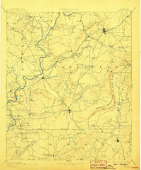
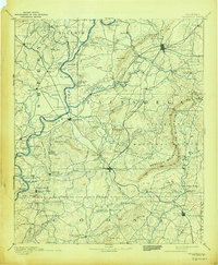
1892 Map of Talladega
USGS Topo · Published 1908About this map
The Coosa River serves as the vital lifeline through this part of Alabama, defined by a series of ferries such as Grissom Ferry, Glover Ferry, and Chancelor Ferry that connected remote settlements before the era of modern bridges. The landscape transitions from the river valley into the prominent Rebecca Mountains or Blue Ridge and the Kahatchee Mountains, where the elevation creates natural bottlenecks like Bull Gap and Fulton Gap. These gaps dictated the paths of the East Tennessee Virginia and Georgia Railroad and other rail lines that fueled the local economy.
Find a feature on this map
141 named features on this map. Tap any name to fly to it.
Don’t see what you’re looking for? This feature index may not catch every label — zoom into the map to look around manually.
Map Details
Editions of this 1892 Talladega Map
6 editions found
Other maps of this area

1889 · Springville
USGS Topo · 1:125,000

1889 · Birmingham
USGS Topo · 1:125,000

1890 · Bessemer
USGS Topo · 1:125,000

1890 · Talladega
USGS Topo · 1:125,000

1891 · Clanton
USGS Topo · 1:125,000

1891 · Ashland
USGS Topo · 1:125,000

1892 · Birmingham
USGS Topo · 1:125,000

1892 · Springville
USGS Topo · 1:125,000

1892 · Talladega
USGS Topo · 1:125,000

1892 · Bessemer
USGS Topo · 1:125,000