
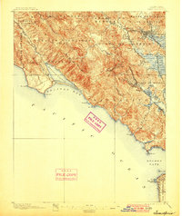
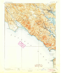
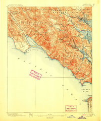
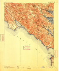
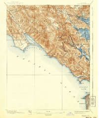
1897 Map of Tamalpais
USGS Topo · Published 1950About this map
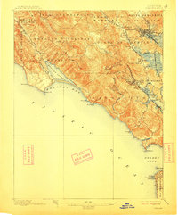
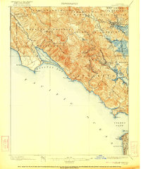
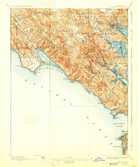
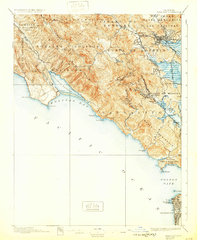
Mt. Tamalpais anchors this coastal landscape, rising above the redwood canyons of Muir Woods National Monument and the developing rail-corridor towns of southern Marin. The map captures the late 19th-century transition from Mexican land grant ranching to suburban growth, as the Northwestern Pacific railroad connects towns like San Rafael, Mill Valley, and Larkspur toward the ferry terminals. Along the rugged Pacific coast, the topography details the steep cliffs from Pt. Bonita and the Fort Barry Military Reservation up to Bolinas Lagoon. In the south, the survey reaches across the Golden Gate to depict the very edge of San Francisco, featuring landmarks like the Cliff House and the Pt. Lobos shoreline. The presence of numerous large ranch boundaries, such as San Geronimo and Las Baulines, reflects the area's agricultural heritage even as modern settlements were taking root.
Find a feature on this map
66 named features on this map. Tap any name to fly to it.
Don’t see what you’re looking for? This feature index may not catch every label — zoom into the map to look around manually.
Map Details
Editions of this 1897 Tamalpais Map
12 editions found

1897 edition
16.6 x 20.7 inches
1900 edition
16.6 x 19.8 inches
1905 edition
16.6 x 19.8 inches
1907 edition
16.6 x 20 inches
1910 edition
16.6 x 19.8 inches
1913 edition
16.6 x 20 inches
1922 edition
16.6 x 19.9 inches
1928 edition
16.6 x 19.9 inches
1932 edition
16.6 x 19.9 inches
1940 edition
16.6 x 19.7 inches
1945 edition
17 x 20.7 inches
1950 edition
16.6 x 20.6 inches
Historical Maps of San Francisco Through Time
58 maps found
1897 Tamalpais
Marin County, CA

1916 Point Reyes
Marin County, CA

1918 Point Reyes
Marin County, CA

1941 Tamalpais
Marin County, CA

1947 San Quentin
Marin County, CA

1948 San Quentin
Marin County, CA

1950 Mt. Tamalpais
Marin County, CA

1951 Petaluma Point
Marin County, CA

1953 Drakes Bay
Marin County, CA

1954 Double Point
Marin County, CA

1954 Point Bonita
Marin County, CA

1954 Point Reyes
Marin County, CA

1954 Point Reyes NE
Marin County, CA

1959 Petaluma Point
Marin County, CA

1959 San Quentin
Marin County, CA

1993 Double Point
Marin County, CA

1993 Point Bonita
Marin County, CA

1993 San Quentin
Marin County, CA

1994 Double Point
Marin County, CA

1995 Drakes Bay
Marin County, CA

1995 Point Reyes NE
Marin County, CA

1995 San Quentin
Marin County, CA

2012 Double Point
Marin County, CA

2012 Drakes Bay
Marin County, CA

2012 Drakes Bay OE S
Marin County, CA

2012 Drakes Bay OE SW
Marin County, CA

2012 Drakes Bay OE W
Marin County, CA

2012 Petaluma Point
Marin County, CA

2012 Point Bonita
Marin County, CA

2012 Point Reyes NE
Marin County, CA

2012 San Quentin
Marin County, CA

2015 Double Point
Marin County, CA

2015 Drakes Bay
Marin County, CA

2015 Drakes Bay OE S
Marin County, CA

2015 Drakes Bay OE SW
Marin County, CA

2015 Drakes Bay OE W
Marin County, CA

2015 Petaluma Point
Marin County, CA

2015 Point Bonita
Marin County, CA

2015 Point Reyes NE
Marin County, CA

2015 San Quentin
Marin County, CA

2018 Double Point
Marin County, CA

2018 Drakes Bay
Marin County, CA

2018 Drakes Bay OE S
Marin County, CA

2018 Drakes Bay OE SW
Marin County, CA

2018 Drakes Bay OE W
Marin County, CA

2018 Petaluma Point
Marin County, CA

2018 Point Bonita
Marin County, CA

2018 Point Reyes NE
Marin County, CA

2018 San Quentin
Marin County, CA

2021 Double Point
Marin County, CA

2021 Drakes Bay
Marin County, CA

2021 Drakes Bay OE S
Marin County, CA

2021 Drakes Bay OE SW
Marin County, CA

2021 Drakes Bay OE W
Marin County, CA

2021 Point Bonita
Marin County, CA

2021 Point Reyes NE
Marin County, CA

2021 San Quentin
Marin County, CA

2022 Petaluma Point
Marin County, CA