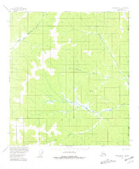
1956 Map of Tanacross C-1
USGS Topo · Published 1981About this map
East Fork Dennison Fork and several unnamed tributaries wind through this high-latitude terrain along the Alaska Yukon boundary. Surveyed in the mid-1950s, the map documents a region defined by its isolation and lack of permanent infrastructure, save for a few isolated landmarks. A Winter Trail cuts across the northwest corner, suggesting the seasonal nature of movement in this subarctic environment where frozen ground and snowpack facilitate travel better than the marshy summer thaw. Small Cabin sites are the only signs of human habitation, likely serving as shelters for trappers or prospectors working along Big Creek or McElfish Creek. Survey markers like VABM 4007 Interior and VABM 3208 Timber denote the high points used for the triangulation of this borderland, where the United States Canada line meets the vast interior of the Tanacross region.
Find a feature on this map
11 named features on this map. Tap any name to fly to it.
Don’t see what you’re looking for? This feature index may not catch every label — zoom into the map to look around manually.
Map Details
Editions of this 1956 Tanacross C-1 Map
3 editions found
Other maps of this area

1949 · Tanacross
USGS Topo · 1:250,000

1950 · Tanacross
USGS Topo · 1:250,000

1956 · Tanacross C-1
USGS Topo · 1:63,360

1956 · Tanacross D-2
USGS Topo · 1:63,360
1956 · Tanacross B-1
USGS Topo · 1:63,360

1956 · Tanacross C-2
USGS Topo · 1:63,360

1956 · Tanacross D-1
USGS Topo · 1:63,360
1956 · Tanacross B-2
USGS Topo · 1:63,360

1956 · Tanacross
USGS Topo · 1:250,000

1964 · Tanacross
USGS Topo · 1:250,000