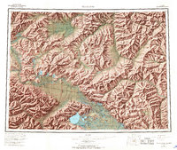
1956 Map of Tanacross
USGS Topo · Published 1968About this map
The Tanana River corridor serves as the primary artery for travel and settlement in this Interior Alaska landscape during the mid-20th century. The map illustrates a critical infrastructure hub at the confluence of the Alaska Highway, Taylor Highway, and Glenn Highway, centering on the burgeoning community of Tok and the nearby Tanacross Airport. South of the river, the Tetlin Indian Reservation encompasses a vast wetland complex including Tetlin Lake and numerous smaller bodies such as Dathlalmund Lake and Titus Paul Lake.
Find a feature on this map
79 named features on this map. Tap any name to fly to it.
Don’t see what you’re looking for? This feature index may not catch every label — zoom into the map to look around manually.
Map Details
Editions of this 1956 Tanacross Map
5 editions found

Other maps of this area

1899 · Fortymile
USGS Topo · 1:250,000

1948 · Tanacross B-5
USGS Topo · 1:63,360

1948 · Tanacross A-6
USGS Topo · 1:63,360

1948 · Tanacross A-3
USGS Topo · 1:63,360

1948 · Tanacross A-4
USGS Topo · 1:63,360

1948 · Nabesna D-5
USGS Topo · 1:63,360

1948 · Tanacross A-5
USGS Topo · 1:63,360

1948 · Tanacross B-3
USGS Topo · 1:63,360

1949 · Tanacross
USGS Topo · 1:250,000

1949 · Tanacross B-4
USGS Topo · 1:63,360