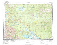
1956 Map of Tanacross
USGS Topo · Published 1987About this map
The Tanana River corridor serves as the central artery of this interior landscape, where traditional settlements and mid-century infrastructure meet. At the junction of the Alaska Highway and the Taylor Highway, the strategic importance of Tok and Tetlin Junction is clear, anchoring the regional transport network. Further south, the map details the intricate waterways of the Tetlin National Wildlife Refuge, where the Tetlin River connects Tetlin Lake to the broader river system. Indigenous heritage is reflected in sites like Tetlin, Last Tetlin Village, and Tanacross, which were surveyed between 1948 and 1956. Higher elevations are marked by distinctive landmarks such as Prindle Volcano and Mount Fairplay, while the eastern boundary traces the Alaska Yukon border, illustrating the remote connectivity between the United States and Canada through river valleys like the Ladus River.
Find a feature on this map
52 named features on this map. Tap any name to fly to it.
Don’t see what you’re looking for? This feature index may not catch every label — zoom into the map to look around manually.
Map Details
Editions of this 1956 Tanacross Map
5 editions found

Other maps of this area

1899 · Fortymile
USGS Topo · 1:250,000

1948 · Tanacross B-5
USGS Topo · 1:63,360

1948 · Tanacross A-6
USGS Topo · 1:63,360

1948 · Tanacross A-3
USGS Topo · 1:63,360

1948 · Tanacross A-4
USGS Topo · 1:63,360

1948 · Nabesna D-5
USGS Topo · 1:63,360

1948 · Tanacross A-5
USGS Topo · 1:63,360

1948 · Tanacross B-3
USGS Topo · 1:63,360

1949 · Tanacross
USGS Topo · 1:250,000

1949 · Tanacross B-4
USGS Topo · 1:63,360