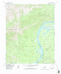
1956 Map of Tanana C-1
USGS Topo · Published 1976About this map
The Yukon River carves a sweeping path through the center of this terrain, serving as the primary corridor for movement and settlement during the mid-1950s. Near the river's bend, the village of Rampart stands as a focal point, supported by a nearby Landing Strip and the Agricultural Sta (Alaska U). This small hub reflects the reliance on river and air access in the Alaskan interior before modern highway networks reached these latitudes.
Find a feature on this map
25 named features on this map. Tap any name to fly to it.
Don’t see what you’re looking for? This feature index may not catch every label — zoom into the map to look around manually.
Map Details
Editions of this 1956 Tanana C-1 Map
3 editions found
Other maps of this area

1945 · Livengood
USGS Topo · 1:250,000

1951 · Tanana
USGS Topo · 1:250,000

1951 · Livengood
USGS Topo · 1:250,000

1956 · Tanana B-1
USGS Topo · 1:63,360

1956 · Tanana C-1
USGS Topo · 1:63,360

1956 · Livengood B-6
USGS Topo · 1:63,360

1956 · Livengood C-6
USGS Topo · 1:63,360

1956 · Livengood D-6
USGS Topo · 1:63,360

1956 · Tanana D-2
USGS Topo · 1:63,360

1956 · Tanana B-2
USGS Topo · 1:63,360