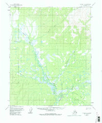
1956 Map of Tanana C-5
USGS Topo · Published 1976About this map
Tozitna River drainage patterns define this remote interior landscape during the mid-1950s, characterized by an extensive network of meandering waterways and wetlands. The region's primary transit route is the Tanana-Allakaket Winter Trail, which cuts a diagonal path across the terrain, crossing Dagislakhna Creek and several unnamed tributaries. This trail system represents the vital seasonal infrastructure of the Alaskan interior before the expansion of more permanent road networks.
Find a feature on this map
10 named features on this map. Tap any name to fly to it.
Don’t see what you’re looking for? This feature index may not catch every label — zoom into the map to look around manually.
Map Details
Editions of this 1956 Tanana C-5 Map
3 editions found
Other maps of this area

1951 · Tanana
USGS Topo · 1:250,000

1956 · Tanana B-5
USGS Topo · 1:63,360

1956 · Tanana D-4
USGS Topo · 1:63,360

1956 · Tanana B-6
USGS Topo · 1:63,360

1956 · Tanana C-6
USGS Topo · 1:63,360

1956 · Tanana D-6
USGS Topo · 1:63,360

1956 · Tanana C-5
USGS Topo · 1:63,360
1956 · Tanana D-5
USGS Topo · 1:63,360

1956 · Tanana C-4
USGS Topo · 1:63,360

1956 · Tanana B-4
USGS Topo · 1:63,360