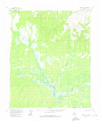
1956 Map of Tanana C-5
USGS Topo · Published 1976About this map
The Tozitna River meanders through a landscape defined by extensive wetlands and seasonal corridors in this mid-century survey of the Alaska interior. The primary overland route through this wilderness is the Tanana-Allakaket Winter Trail, which traverses the region from north to south, crossing the marshy lowlands of Dagislakhna Creek. This trail network represents a critical historical transportation link for the Yukon-Koyukuk region, facilitating movement when the ground was frozen and the complex waterways were impassable. Numerous tributaries, including Banddana Creek and the curiously named Wrongtrail Creek, feed into the river system, illustrating the intricate drainage patterns that dictated travel and seasonal land use. The topography reveals significant relief to the north near the North Fork, contrasting with the saturated basins further south.
Find a feature on this map
9 named features on this map. Tap any name to fly to it.
Don’t see what you’re looking for? This feature index may not catch every label — zoom into the map to look around manually.
Map Details
Editions of this 1956 Tanana C-5 Map
3 editions found
Other maps of this area

1951 · Tanana
USGS Topo · 1:250,000

1956 · Tanana B-5
USGS Topo · 1:63,360

1956 · Tanana D-4
USGS Topo · 1:63,360

1956 · Tanana B-6
USGS Topo · 1:63,360

1956 · Tanana C-6
USGS Topo · 1:63,360

1956 · Tanana D-6
USGS Topo · 1:63,360

1956 · Tanana C-5
USGS Topo · 1:63,360
1956 · Tanana D-5
USGS Topo · 1:63,360

1956 · Tanana C-4
USGS Topo · 1:63,360

1956 · Tanana B-4
USGS Topo · 1:63,360