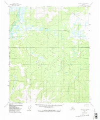
1956 Map of Tanana C-6
USGS Topo · Published 1987About this map
Tanana-Allakaket Winter Trail cuts across the northern reaches of this landscape, marking a vital historical corridor through the interior of the Yukon-Koyukuk region. In this mid-century environment, the convergence of the Melozitna River and Klutakhna River defines the drainage patterns of a largely roadless territory. The map reveals a complex web of drainages including Haha Creek, Dagistakhna Creek, and the aptly named Wrongtrail Creek, which flow around high points like Nuklauket Pass. This survey reflects the era before modern development, where land lines remained unsurveyed and predetermined by the Bureau of Land Management, as evidenced by the Fairbanks Meridian Boundary West. The prevalence of wetlands and seasonal watercourses like Melozimoran Creek indicates a terrain shaped by the ebb and flow of Arctic waters, captured here through 1952 aerial photography and 1956 field annotation.
Find a feature on this map
9 named features on this map. Tap any name to fly to it.
Don’t see what you’re looking for? This feature index may not catch every label — zoom into the map to look around manually.
Map Details
Editions of this 1956 Tanana C-6 Map
3 editions found
Other maps of this area

1951 · Melozitna
USGS Topo · 1:250,000

1951 · Tanana
USGS Topo · 1:250,000

1952 · Melozitna D-1
USGS Topo · 1:63,360

1956 · Melozitna C-1
USGS Topo · 1:63,360

1956 · Melozitna B-1
USGS Topo · 1:63,360

1956 · Tanana B-5
USGS Topo · 1:63,360

1956 · Tanana B-6
USGS Topo · 1:63,360

1956 · Tanana C-6
USGS Topo · 1:63,360

1956 · Tanana D-6
USGS Topo · 1:63,360

1956 · Tanana C-5
USGS Topo · 1:63,360