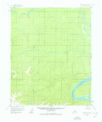
1956 Map of Tanana D-1
USGS Topo · Published 1976About this map
The Yukon River cuts through the southeastern corner of this Alaskan interior landscape, a primary artery for travel and trade in the mid-1950s. Near the river's edge, human activity is evidenced by isolated Cabins and unidentified Ruins located across from Kalka Island. This survey represents the era before modern development, where land lines remained unsurveyed and unmarked locations were predetermined by the Bureau of Land Management.
Find a feature on this map
11 named features on this map. Tap any name to fly to it.
Don’t see what you’re looking for? This feature index may not catch every label — zoom into the map to look around manually.
Map Details
Editions of this 1956 Tanana D-1 Map
4 editions found

Other maps of this area

1945 · Livengood
USGS Topo · 1:250,000

1951 · Bettles
USGS Topo · 1:250,000

1951 · Tanana
USGS Topo · 1:250,000

1951 · Livengood
USGS Topo · 1:250,000

1951 · Beaver
USGS Topo · 1:250,000

1956 · Bettles
USGS Topo · 1:250,000

1956 · Tanana C-1
USGS Topo · 1:63,360

1956 · Livengood C-6
USGS Topo · 1:63,360

1956 · Beaver
USGS Topo · 1:250,000

1956 · Livengood D-6
USGS Topo · 1:63,360