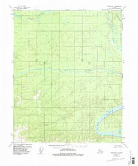
1956 Map of Tanana D-1
USGS Topo · Published 1987About this map
The Yukon River sweeps through the southeast corner of this interior Alaskan landscape, a region defined by its complex drainage network and isolated outposts. Based on 1950s field data with 1970s revisions, the map reveals the industrial imposition of the Trans-Alaska Pipeline cutting across the northeast. Away from this modern corridor, the terrain remains dominated by the winding paths of the Ray River and the Big Salt River, where several Cabins signify the sparse human presence in this wilderness. High points like VABM 2492 Ray and VABM 1585 Trail provide surveying benchmarks overlooking numerous tributaries, including Salt Creek and the aptly named Dreamland Creek. The riverine environment is further detailed by features such as Kalka Island, illustrating the shifting bars and channels of the great northern waterways during the mid-twentieth century.
Find a feature on this map
11 named features on this map. Tap any name to fly to it.
Don’t see what you’re looking for? This feature index may not catch every label — zoom into the map to look around manually.
Map Details
Editions of this 1956 Tanana D-1 Map
4 editions found

Other maps of this area

1945 · Livengood
USGS Topo · 1:250,000

1951 · Bettles
USGS Topo · 1:250,000

1951 · Tanana
USGS Topo · 1:250,000

1951 · Livengood
USGS Topo · 1:250,000

1951 · Beaver
USGS Topo · 1:250,000

1956 · Bettles
USGS Topo · 1:250,000

1956 · Tanana C-1
USGS Topo · 1:63,360

1956 · Livengood C-6
USGS Topo · 1:63,360

1956 · Beaver
USGS Topo · 1:250,000

1956 · Livengood D-6
USGS Topo · 1:63,360