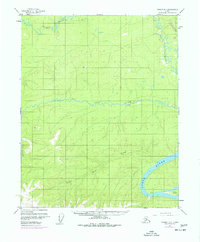
1956 Map of Tanana D-1
USGS Topo · Published 1977About this map
The Yukon River sweeps through the southeastern corner of this Alaskan interior landscape, a vital corridor for travel and survival long before modern infrastructure arrived. Revisions from 1975 capture a significant moment in the state's industrial history, showing the Trans-Alaska Pipeline (Under Construction) as it began to cut through the wilderness near the Ray River. The rugged topography is defined by major drainages like the Big Salt River and the meandering Little Salt Creek, which together shape the region's complex watershed.
Find a feature on this map
12 named features on this map. Tap any name to fly to it.
Don’t see what you’re looking for? This feature index may not catch every label — zoom into the map to look around manually.
Map Details
Editions of this 1956 Tanana D-1 Map
4 editions found

Other maps of this area

1945 · Livengood
USGS Topo · 1:250,000

1951 · Bettles
USGS Topo · 1:250,000

1951 · Tanana
USGS Topo · 1:250,000

1951 · Livengood
USGS Topo · 1:250,000

1951 · Beaver
USGS Topo · 1:250,000

1956 · Bettles
USGS Topo · 1:250,000

1956 · Tanana C-1
USGS Topo · 1:63,360

1956 · Livengood C-6
USGS Topo · 1:63,360

1956 · Beaver
USGS Topo · 1:250,000

1956 · Livengood D-6
USGS Topo · 1:63,360