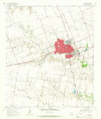
1964 Map of Taylor
USGS Topo · Published 1966About this map
The railroad town of Taylor serves as the focal point of this mid-1960s survey, defined by the junction of the Missouri Pacific and Missouri Kansas Texas railroads. The town's grid is densely packed with civic institutions, including The Johns Hospital, The Johns Clinic, and a series of neighborhood schools such as West End Sch and Price Sch. A cultural landscape of local significance is visible in the distribution of religious and commemorative sites, from Memorial Ch to the City Cemetery and St Marys Cem.
Find a feature on this map
43 named features on this map. Tap any name to fly to it.
Don’t see what you’re looking for? This feature index may not catch every label — zoom into the map to look around manually.
Map Details
Editions of this 1964 Taylor Map
3 editions found
Other maps of this area

1885 · Taylor
USGS Topo · 1:125,000

1885 · Bastrop
USGS Topo · 1:125,000

1887 · Taylor
USGS Topo · 1:125,000

1893 · Georgetown
USGS Topo · 1:125,000

1893 · Bastrop
USGS Topo · 1:125,000

1894 · Taylor
USGS Topo · 1:125,000

1896 · Austin
USGS Topo · 1:125,000

1897 · Austin
USGS Topo · 1:125,000

1904 · Bastrop
USGS Topo · 1:125,000

1910 · Austin
USGS Topo · 1:125,000