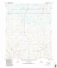
1950 Map of Teller D-1
USGS Topo · Published 1988About this map
The Bering Land Bridge National Preserve dominates the northern reaches of this landscape, where the Serpentine River and its South Fork Serpentine River wind through a complex network of wetlands and tundra. To the south, the terrain rises toward the Continental Divide, a prominent geological boundary that separates the north-flowing waters from the drainage of East Portage Creek. Historical activity is marked by a remote Cabin near the eastern edge and a legacy of overland travel preserved in the Winter Trail. Small-scale engineering is visible through a labeled Ditch near McKinley Creek, hinting at early resource extraction or water management efforts. The geography is punctuated by isolated peaks such as Lone Butte and Pinnacle 978, which served as essential landmarks for navigation across this unpopulated interior at mid-century.
Find a feature on this map
23 named features on this map. Tap any name to fly to it.
Don’t see what you’re looking for? This feature index may not catch every label — zoom into the map to look around manually.
Map Details
Editions of this 1950 Teller D-1 Map
4 editions found

Other maps of this area

1950 · Bendeleben C-6
USGS Topo · 1:63,360

1950 · Bendeleben D-6
USGS Topo · 1:63,360

1950 · Teller
USGS Topo · 1:250,000

1950 · Bendeleben
USGS Topo · 1:250,000

1950 · Shishmaref
USGS Topo · 1:250,000

1950 · Shishmaref A-1
USGS Topo · 1:63,360

1950 · Kotzebue A-6
USGS Topo · 1:63,360

1950 · Teller D-2
USGS Topo · 1:63,360

1950 · Shishmaref A-2
USGS Topo · 1:63,360

1950 · Teller C-2
USGS Topo · 1:63,360