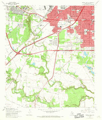
1967 Map of Terrell Wells
USGS Topo · Published 1969This historical map portrays the area of Terrell Wells in 1967, primarily covering Bexar County. Featuring a scale of 1:24000, this map provides a highly detailed snapshot of the terrain, roads, buildings, counties, and historical landmarks in the Terrell Wells region at the time. Published in 1969, it is one of 3 known editions of this map due to revisions or reprints.
Find a feature on this map
87 named features on this map. Tap any name to fly to it.
Don’t see what you’re looking for? This feature index may not catch every label — zoom into the map to look around manually.
Map Details
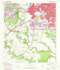
Editions of this 1967 Terrell Wells Map
3 editions found
Historical Maps of Bexar County Through Time
31 maps found

1953 Culebra Hill
Bexar County, TX

1953 Longhorn
Bexar County, TX

1953 Martinez
Bexar County, TX

1953 Otis Ridge
Bexar County, TX

1953 San Antonio East
Bexar County, TX

1953 San Antonio West
Bexar County, TX

1953 Southton
Bexar County, TX

1953 Terrell Wells
Bexar County, TX

1953 Van Raub
Bexar County, TX

1958 Losoya
Bexar County, TX

1958 Saint Hedwig
Bexar County, TX

1958 Thelma
Bexar County, TX

1965 Camp Bullis
Bexar County, TX

1966 Culebra Hill
Bexar County, TX

1967 Longhorn
Bexar County, TX

1967 Martinez
Bexar County, TX

1967 San Antonio East
Bexar County, TX

1967 San Antonio West
Bexar County, TX

1967 Southton
Bexar County, TX

1967 Terrell Wells
Bexar County, TX

1967 Van Raub
Bexar County, TX

1991 Van Raub
Bexar County, TX

1992 Camp Bullis
Bexar County, TX

1992 Longhorn
Bexar County, TX

1992 Martinez
Bexar County, TX

1992 Saint Hedwig
Bexar County, TX

1992 San Antonio East
Bexar County, TX

1992 Southton
Bexar County, TX

1992 Terrell Wells
Bexar County, TX

1993 Culebra Hill
Bexar County, TX

1993 San Antonio West
Bexar County, TX