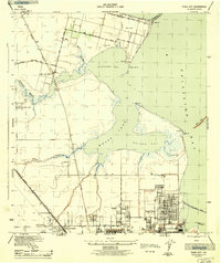
1943 Map of Texas City
USGS Topo · Published 1943About this map
The industrial and coastal landscape of Texas City is documented here just as it became a critical wartime hub. The map highlights the extensive grid of the city and its neighboring communities like Lamarque and Heights, alongside the burgeoning port infrastructure at Pier A and Pier O. This 1943 survey, produced by the Tennessee Valley Authority for the War Department, provides a clear view of the Southern Pacific rail lines and the San Leon Station that connected these coastal settlements to the broader Houston region. Along the shores of Galveston Bay and Dickinson Bay, the geography is defined by prominent points such as April Fool Pt and Miller Pt, while the massive Texas City Dike stretches into the water to protect the channel. Smaller settlements like Nadeau and the oil-industry related Humble Camp appear alongside local landmarks like the Airway Beacon and San Leon Cem.
Find a feature on this map
34 named features on this map. Tap any name to fly to it.
Don’t see what you’re looking for? This feature index may not catch every label — zoom into the map to look around manually.
Map Details
Editions of this 1943 Texas City Map
2 editions found
Other maps of this area

1916 · Seabrook
USGS Topo · 1:24,000

1920 · Seabrook
USGS Topo · 1:31,680

1929 · Dickinson
USGS Topo · 1:24,000

1929 · Hitchcock
USGS Topo · 1:24,000

1929 · Virginia Point
USGS Topo · 1:24,000

1929 · Texas City
USGS Topo · 1:24,000

1930 · Galveston
USGS Topo · 1:24,000

1932 · Clifton By The Sea
USGS Topo · 1:31,680

1932 · Dickinson
USGS Topo · 1:31,680
1932 · Seabrook
USGS Topo · 1:31,680