
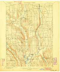
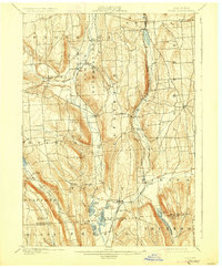
1900 Map of Tully
USGS Topo · Published 1900This historical map portrays the area of Tully in 1900, primarily covering Onondaga as well as portions of Cortland County. Featuring a scale of 1:62500, this map provides a highly detailed snapshot of the terrain, roads, buildings, counties, and historical landmarks in the Tully region at the time. Published in 1900, it is one of 9 known editions of this map due to revisions or reprints.
Find a feature on this map
54 named features on this map. Tap any name to fly to it.
Don’t see what you’re looking for? This feature index may not catch every label — zoom into the map to look around manually.
Map Details
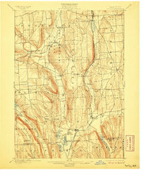
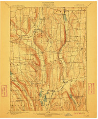
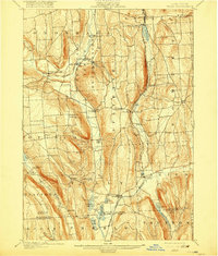
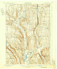
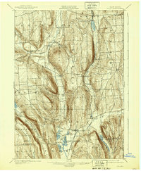
Editions of this 1900 Tully Map
9 editions found
Historical Maps of Cummings Crossing Through Time
45 maps found

1899 Skaneateles
Onondaga County, NY

1900 Tully
Onondaga County, NY

1902 Skaneateles
Onondaga County, NY

1938 Syracuse East
Onondaga County, NY

1939 Syracuse West
Onondaga County, NY

1940 Cicero
Onondaga County, NY

1942 Oran
Onondaga County, NY

1943 Camillus
Onondaga County, NY

1943 Deruyter
Onondaga County, NY

1943 Jamesville
Onondaga County, NY

1943 Lysander
Onondaga County, NY

1943 Manlius
Onondaga County, NY

1943 Marcellus
Onondaga County, NY

1943 Oran
Onondaga County, NY

1943 Otisco Valley
Onondaga County, NY

1943 Skaneateles
Onondaga County, NY

1943 South Onondaga
Onondaga County, NY

1943 Syracuse East
Onondaga County, NY

1943 Tully
Onondaga County, NY

1944 Cicero
Onondaga County, NY

1944 De Ruyter
Onondaga County, NY

1947 Syracuse West
Onondaga County, NY

1949 Jamesville
Onondaga County, NY

1949 Skaneateles
Onondaga County, NY

1955 Camillus
Onondaga County, NY

1955 Jamesville
Onondaga County, NY

1955 Lysander
Onondaga County, NY

1955 Marcellus
Onondaga County, NY

1955 Otisco Valley
Onondaga County, NY

1955 Skaneateles
Onondaga County, NY

1955 Skaneateles
Onondaga County, NY

1955 South Onondaga
Onondaga County, NY

1955 Tully
Onondaga County, NY

1955 Tully
Onondaga County, NY

1957 Cicero
Onondaga County, NY

1957 Manlius
Onondaga County, NY

1957 Syracuse East
Onondaga County, NY

1958 Syracuse West
Onondaga County, NY

1973 Cicero
Onondaga County, NY

1973 Jamesville
Onondaga County, NY

1973 Manlius
Onondaga County, NY

1973 Oran
Onondaga County, NY

1973 South Onondaga
Onondaga County, NY

1973 Syracuse West
Onondaga County, NY

1977 Syracuse East
Onondaga County, NY