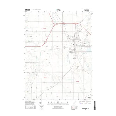
2016 Map of Upper Sandusky
USGS Topo · Published 2016About this map
Upper Sandusky serves as the focal point for this Wyandot County landscape, situated along the winding course of the Sandusky River. The town's historical depth is evident in its collection of memorial sites, including the Old Mission Cem and the Fort Ferree Cem located near the river's edge. This 2016 survey captures the area's transition from the residential street grids of the county seat to the surrounding agricultural flats, marked by an extensive network of drainage features like Vieth Ditch and Hart Ditch. To the south, the village of Harpster anchors the lower portion of the map, while the Upper Sandusky Reservoir provides a significant water feature east of the main town. Researchers will find numerous family-named landmarks and rural burials, such as the Henderson Cem and Oak Hill Cem, which offer essential data for genealogical study in this part of north-central Ohio.
Find a feature on this map
91 named features on this map. Tap any name to fly to it.
Don’t see what you’re looking for? This feature index may not catch every label — zoom into the map to look around manually.
Map Details
Editions of this 2016 Upper Sandusky Map
This is the sole edition of this map. No revisions or reprints were ever made.
Other maps of this area

1903 · Marion
USGS Topo · 1:62,500

1905 · Marion
USGS Topo · 1:62,500

1906 · Sycamore
USGS Topo · 1:62,500

1907 · Upper Sandusky
USGS Topo · 1:62,500

1915 · La Rue
USGS Topo · 1:62,500

1950 · Marion
USGS Topo · 1:250,000

1960 · Sycamore
USGS Topo · 1:24,000

1960 · Nevada
USGS Topo · 1:24,000
1960 · Morral
USGS Topo · 1:24,000

1960 · Upper Sandusky
USGS Topo · 1:24,000