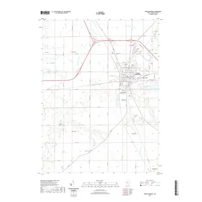
2019 Map of Upper Sandusky
USGS Topo · Published 2019About this map
Upper Sandusky serves as the focal point of this Wyandot County landscape, centered on the Wyandot County Courthouse and a dense network of residential and industrial streets. The town's historical depth is evident in its numerous burial grounds, including the Old Mission Cem and Saint Peters Cem, while the Sandusky River winds along its eastern edge. Beyond the municipal borders, the terrain is defined by an extensive system of agricultural drainage and waterways like Vieth Ditch, Hurt Ditch, and Sugar Run.
Find a feature on this map
95 named features on this map. Tap any name to fly to it.
Don’t see what you’re looking for? This feature index may not catch every label — zoom into the map to look around manually.
Map Details
Editions of this 2019 Upper Sandusky Map
This is the sole edition of this map. No revisions or reprints were ever made.
Other maps of this area

1903 · Marion
USGS Topo · 1:62,500

1905 · Marion
USGS Topo · 1:62,500

1906 · Sycamore
USGS Topo · 1:62,500

1907 · Upper Sandusky
USGS Topo · 1:62,500

1915 · La Rue
USGS Topo · 1:62,500

1950 · Marion
USGS Topo · 1:250,000

1960 · Sycamore
USGS Topo · 1:24,000

1960 · Nevada
USGS Topo · 1:24,000
1960 · Morral
USGS Topo · 1:24,000

1960 · Upper Sandusky
USGS Topo · 1:24,000