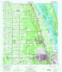
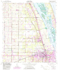
1949 Map of Vero Beach
USGS Topo · Published 1971About this map
The citrus groves and coastal waterways of Indian River County define this mid-century landscape, capturing Vero Beach and its northern neighbors just as the post-war building boom began to expand the city limits. The Florida East Coast Railway and U.S. Highway 1 serve as the primary north-south spine for the settlements of Wabasso, Winter Beach, and Gifford. Along the coast, the intricate geography of the Indian River Narrows is mapped in detail, featuring a network of islands including Johns Island and Pine Island. Revisions from 1970 show the inland expansion of urban areas in purple, illustrating the conversion of agricultural land near the Vero Beach Municipal Airport and the Main Canal into residential developments. Historic landmarks such as Copelands Landing, the Fish Hatchery, and a Drive-in Theater provide specific points of interest for local historians tracing the evolution of Florida's Atlantic coast.
Find a feature on this map
49 named features on this map. Tap any name to fly to it.
Don’t see what you’re looking for? This feature index may not catch every label — zoom into the map to look around manually.
Map Details
Editions of this 1949 Vero Beach Map
6 editions found
Other maps of this area

1948 · Riomar
USGS Topo · 1:24,000

1948 · Indrio
USGS Topo · 1:24,000

1949 · Fellsmere
USGS Topo · 1:24,000

1949 · Vero Beach
USGS Topo · 1:24,000

1949 · Sebastian
USGS Topo · 1:24,000

1949 · Oslo
USGS Topo · 1:24,000

1950 · Riomar
USGS Topo · 1:24,000

1950 · Oslo
USGS Topo · 1:24,000

1950 · Indrio
USGS Topo · 1:24,000

1950 · Vero Beach
USGS Topo · 1:24,000