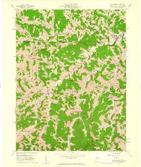
1958 Map of Wadestown
USGS Topo · Published 1961About this map
Battelle and Clay districts of Monongalia County are defined by a deeply dissected landscape of ridges and winding hollows in the late 1950s. The settlement of Wadestown serves as a local hub near the confluence of the West Fork and North Fork, where the West Warren Ch and several cemeteries anchor the community. The topography is dotted with family-named landmarks like Efaw Knob and Lantz Hill, reflecting a long history of upland farming and homesteading.
Find a feature on this map
106 named features on this map. Tap any name to fly to it.
Don’t see what you’re looking for? This feature index may not catch every label — zoom into the map to look around manually.
Map Details
Editions of this 1958 Wadestown Map
4 editions found
Other maps of this area

1901 · Waynesburg
USGS Topo · 1:62,500

1904 · Blacksville
USGS Topo · 1:62,500

1904 · Waynesburg
USGS Topo · 1:62,500

1905 · Mannington
USGS Topo · 1:62,500

1905 · Rogersville
USGS Topo · 1:62,500

1923 · Blacksville
USGS Topo · 1:62,500

1923 · Mannington
USGS Topo · 1:62,500

1925 · Blacksville
USGS Topo · 1:62,500

1926 · Mannington
USGS Topo · 1:62,500

1949 · Clarksburg
USGS Topo · 1:250,000