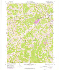
1958 Map of Wadestown
USGS Topo · Published 1977About this map
The rolling drainage of Dunkard Creek and its many branches defines the landscape of the West Virginia-Pennsylvania border during the late 1950s. Small hamlets and crossroads communities like Wadestown and Jollytown anchor a region shaped by agricultural life and the emerging footprint of extractive industry, evidenced by the Strip Mine near Lantz Hill. Local genealogy is deeply etched into the topography through a dense network of family-named landmarks and burial grounds, including the Old Mt Tabor Cem and Handgardner Cem.
Find a feature on this map
79 named features on this map. Tap any name to fly to it.
Don’t see what you’re looking for? This feature index may not catch every label — zoom into the map to look around manually.
Map Details
Editions of this 1958 Wadestown Map
4 editions found
Other maps of this area

1901 · Waynesburg
USGS Topo · 1:62,500

1904 · Blacksville
USGS Topo · 1:62,500

1904 · Waynesburg
USGS Topo · 1:62,500

1905 · Mannington
USGS Topo · 1:62,500

1905 · Rogersville
USGS Topo · 1:62,500

1923 · Blacksville
USGS Topo · 1:62,500

1923 · Mannington
USGS Topo · 1:62,500

1925 · Blacksville
USGS Topo · 1:62,500

1926 · Mannington
USGS Topo · 1:62,500

1949 · Clarksburg
USGS Topo · 1:250,000