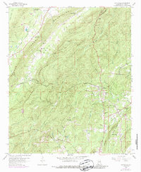
1958 Map of Wattsville
USGS Topo · Published 1987About this map
Wattsville and Coal City serve as the primary hubs in this St. Clair County landscape, which is defined by the industrial and agricultural patterns of the mid-20th century. The presence of Strip Mines and an Old Railroad Grade alongside the active Seaboard Coast Line tracks illustrates the region's reliance on mineral extraction and rail transport. The topography is dominated by the parallel alignment of Backbone Mountain and Savages Mountain, creating a corridor for Broken Arrow Creek and the Dixie Heart Highway. Rural community life is anchored by numerous small congregations such as Harkey Chapel, Shiloh Ch, and Popes Chapel, as well as the Coal City Sch. Distinctive landmarks like Moon Rock and the Hardwick Tunnel reflect the intersection of natural geology and human engineering in the Shoal Creek Valley.
Find a feature on this map
54 named features on this map. Tap any name to fly to it.
Don’t see what you’re looking for? This feature index may not catch every label — zoom into the map to look around manually.
Map Details
Editions of this 1958 Wattsville Map
4 editions found
Other maps of this area

1889 · Springville
USGS Topo · 1:125,000

1892 · Springville
USGS Topo · 1:125,000

1947 · Cox Gap
USGS Topo · 1:24,000

1947 · Ragland
USGS Topo · 1:62,500

1947 · Ragland
USGS Topo · 1:24,000

1947 · Riverside
USGS Topo · 1:24,000

1947 · Steele
USGS Topo · 1:62,500

1953 · Birmingham
USGS Topo · 1:250,000

1956 · Birmingham
USGS Topo · 1:250,000

1957 · Birmingham
USGS Topo · 1:250,000