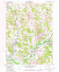
1961 Map of Waynesburg
USGS Topo · Published 1978About this map
Extensive extractive industry dominates the hills surrounding Waynesburg and East Sparta in the early 1960s. The landscape is heavily marked by numerous Strip Mines, which are clustered across the northern townships of Canton and Osnaburg. This industrial activity exists alongside older land divisions, most notably the North Boundary United States Military District and the Geographers Line, which intersect the terrain near Magnolia.
Find a feature on this map
63 named features on this map. Tap any name to fly to it.
Don’t see what you’re looking for? This feature index may not catch every label — zoom into the map to look around manually.
Map Details
Editions of this 1961 Waynesburg Map
4 editions found
Other maps of this area

1901 · Canton
USGS Topo · 1:62,500

1903 · Canton
USGS Topo · 1:62,500

1909 · Alliance
USGS Topo · 1:62,500

1910 · Carrollton
USGS Topo · 1:62,500

1912 · Dover
USGS Topo · 1:62,500

1912 · Carrollton
USGS Topo · 1:62,500

1944 · Dover
USGS Topo · 1:62,500

1951 · Canton
USGS Topo · 1:250,000

1951 · Bolivar
USGS Topo · 1:24,000

1953 · Canton
USGS Topo · 1:250,000