
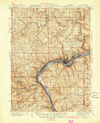
1944 Map of Wellsville
USGS Topo · Published 1944About this map
Wellsville and East Liverpool anchor this tri-state industrial landscape where the Ohio River cuts through the steep hills of Columbiana County. The mid-century river economy is fully evident, showing the Pennsylvania RR and its New Cumberland Branch hugging the banks to serve riverfront pottery and steel towns like Chester, Newell, and Congo. Beyond the urban centers, the map documents a dense network of smaller settlements including Hammondsville, Irondale, and Pughtown PO, many of which were built around the region's clay and coal resources. Significant watercourses like the Little Beaver River and Yellow Creek meander toward the Ohio, passing landmarks such as Grimms Bridge and the Nessly Chapel. This survey effectively captures the high-water mark of the region's heavy manufacturing era before the transition to the modern industrial landscape.
Find a feature on this map
76 named features on this map. Tap any name to fly to it.
Don’t see what you’re looking for? This feature index may not catch every label — zoom into the map to look around manually.
Map Details
Editions of this 1944 Wellsville Map
2 editions found
Other maps of this area

1901 · Cadiz
USGS Topo · 1:62,500

1901 · Beaver
USGS Topo · 1:62,500

1902 · New Castle
USGS Topo · 1:62,500

1903 · Cadiz
USGS Topo · 1:62,500

1904 · Newcastle
USGS Topo · 1:62,500

1904 · Wellsville
USGS Topo · 1:62,500

1904 · Steubenville
USGS Topo · 1:62,500

1904 · Beaver
USGS Topo · 1:62,500

1904 · Burgettstown
USGS Topo · 1:62,500

1905 · Salineville
USGS Topo · 1:62,500