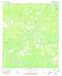
1963 Map of Whitehall
USGS Topo · Published 1981About this map
The confluence of the Amite River and the Tickfaw River defines this swampy landscape, where early 1960s settlements like Whitehall and Maurepas cling to the slightly higher ground. The map reveals a transition in Louisiana's interior transportation, showing an Old Railroad Grade that once cut through the marshy lowland near Pocket Island and Whitehall Coteau. Human settlement is marked by numerous family and community landmarks, including the Redding Cem and Pennington Cem in the northeast, alongside spiritual centers like Zion Ch and Maurepas Ch. Water dominates the geography, with named reaches and landings such as Horse Bluff Landing and Tiger Bluff Landing serving as vital access points along the winding bayous. Further south, the intricate network of Chene Blanc Bayou and Bayou Chinquapin illustrates the complex drainage system of the Livingston Parish wetlands.
Find a feature on this map
50 named features on this map. Tap any name to fly to it.
Don’t see what you’re looking for? This feature index may not catch every label — zoom into the map to look around manually.
Map Details
Editions of this 1963 Whitehall Map
4 editions found
Other maps of this area

1892 · Mount Airy
USGS Topo · 1:62,500

1892 · Donaldsonville
USGS Topo · 1:62,500

1934 · Denham Springs
USGS Topo · 1:62,500

1934 · Springfield
USGS Topo · 1:62,500

1939 · Springfield
USGS Topo · 1:62,500

1939 · Denham Springs
USGS Topo · 1:62,500

1939 · Donaldsonville
USGS Topo · 1:62,500

1946 · North of Garyville
USGS Topo · 1:31,680

1946 · Petite Amite River
USGS Topo · 1:31,680

1947 · Sorrento
USGS Topo · 1:31,680