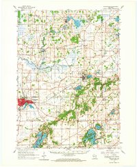
1960 Map of Whitewater
USGS Topo · Published 1967About this map
Whitewater serves as the primary urban hub on this 1960s survey, home to the Wisconsin State College campus and essential rail connections provided by the Milwaukee Road. The landscape is defined by the glacial legacy of the Kettle Moraine State Forest, where the terrain is punctuated by numerous lakes and ponds, including Blue Spring Lake and the Lauderdale Lakes. The presence of the Cushman Mill Site and several small settlements like Rome and Hebron reflects an economy deeply tied to the local water systems. Rural life is well-documented through a dense network of country schools such as Corner Grove Sch and family-named cemeteries like Hoffman Cem and Murray Cem. The map captures the region before extensive modern development, showing the original footprint of Palmyra and the surrounding agricultural prairies.
Find a feature on this map
74 named features on this map. Tap any name to fly to it.
Don’t see what you’re looking for? This feature index may not catch every label — zoom into the map to look around manually.
Map Details
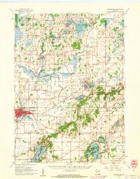
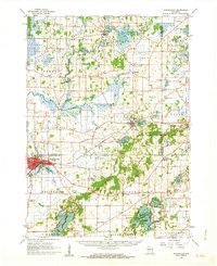
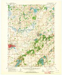
Editions of this 1960 Whitewater Map
4 editions found
Other maps of this area

1891 · Waterloo
USGS Topo · 1:62,500

1891 · Koshkonong
USGS Topo · 1:62,500

1892 · Watertown
USGS Topo · 1:62,500

1892 · Oconomowoc
USGS Topo · 1:62,500

1892 · Whitewater
USGS Topo · 1:62,500

1892 · Eagle
USGS Topo · 1:62,500

1893 · Delavan
USGS Topo · 1:62,500

1893 · Whitewater
USGS Topo · 1:62,500

1893 · Shopiere
USGS Topo · 1:62,500

1893 · Geneva
USGS Topo · 1:62,500