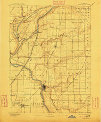
1892 Map of Wilmington
USGS Topo · Published 1911About this map
The confluence of the Desplaines River, Kankakee River, and Dupage River anchors this late nineteenth-century portrait of Will County. A complex transportation corridor defines the landscape, where the Michigan and Mississippi Canal runs parallel to the Chicago Rock Island and Pacific Railway near Channahon. This industrial and transit network facilitated the growth of several distinct settlements, from the established center of Wilmington to smaller hubs like Elwood and Symerton. The map captures the region at a transitional moment when water-based transport was being superseded by an extensive grid of competing rail lines, including the Chicago and Alton Railway and the Wabash Railway. In the southwest corner, the proximity of Braidwood and Diamond reflects the early coal mining activity that drew thousands of workers to this prairie environment, while rural townships like Florence and Wesley remain largely agricultural.
Find a feature on this map
39 named features on this map. Tap any name to fly to it.
Don’t see what you’re looking for? This feature index may not catch every label — zoom into the map to look around manually.
Map Details
Editions of this 1892 Wilmington Map
3 editions found
Other maps of this area

1890 · Des Plaines
USGS Topo · 1:62,500

1892 · Morris
USGS Topo · 1:62,500

1892 · Joliet
USGS Topo · 1:62,500

1892 · Wilmington
USGS Topo · 1:62,500

1894 · Des Plaines
USGS Topo · 1:62,500

1900 · Des Plaines
USGS Topo · 1:62,500

1901 · Des Plaines
USGS Topo · 1:62,500

1918 · Wilmington
USGS Topo · 1:62,500

1918 · Morris
USGS Topo · 1:62,500

1922 · Kankakee
USGS Topo · 1:62,500