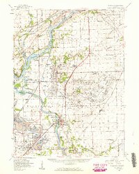
1954 Map of Wilmington
USGS Topo · Published 1960About this map
The Kankakee River and Des Plaines River converge in this mid-century landscape, a region defined by its industrial waterways and extensive rail network. The historical Illinois and Michigan Canal and the Chicago Sanitary and Ship Canal run parallel in the north, illustrating the evolution of Illinois's water transport. Near Wilmington, the presence of the Soldiers Widows Home and several local schools like Offerman Sch and Eaton Sch mark the social fabric of the day. To the south and west, the terrain shifts toward heavy industry, where Strip Mines, Strip Mine pits, and Mine Dumps dominate the area around Braidwood and Diamond. This survey provides a clear look at the Old Indian Boundary line cutting through Florence and Wilton townships, while cemeteries such as Maple Hill Cem and Bohemian Cem offer valuable points of interest for genealogists.
Find a feature on this map
95 named features on this map. Tap any name to fly to it.
Don’t see what you’re looking for? This feature index may not catch every label — zoom into the map to look around manually.
Map Details
Editions of this 1954 Wilmington Map
3 editions found
Other maps of this area

1890 · Des Plaines
USGS Topo · 1:62,500

1892 · Morris
USGS Topo · 1:62,500

1892 · Joliet
USGS Topo · 1:62,500

1892 · Wilmington
USGS Topo · 1:62,500

1894 · Des Plaines
USGS Topo · 1:62,500

1900 · Des Plaines
USGS Topo · 1:62,500

1901 · Des Plaines
USGS Topo · 1:62,500

1918 · Wilmington
USGS Topo · 1:62,500

1918 · Morris
USGS Topo · 1:62,500

1922 · Kankakee
USGS Topo · 1:62,500